
Топографическая карта St Paul's Walden
Интерактивная карта
Нажмите на карту, чтобы отобразить высоту.
Об этой карте
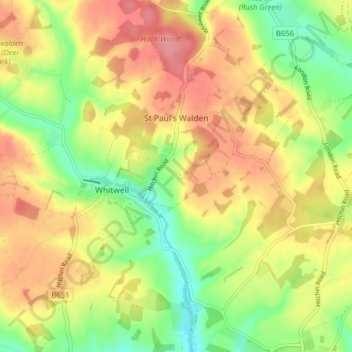
Название: Топографическая карта St Paul's Walden, высота, рельеф.
Местонахождение: St Paul's Walden, North Hertfordshire, Hertfordshire, England, United Kingdom (51.85896 -0.32473 51.89717 -0.24565)
Средняя высота: 121 м
Минимальная высота: 79 м
Максимальная высота: 158 м
Другие топографические карты
Нажмите на карту, чтобы просмотреть ее топографию, ее высоту и ее рельеф.
Hitchin
United Kingdom > England > Hertfordshire > North Hertfordshire
Hitchin, North Hertfordshire, Hertfordshire, England, SG5 1BB, United Kingdom
Средняя высота: 91 м
Great Wymondley
United Kingdom > England > Hertfordshire > North Hertfordshire
Great Wymondley, North Hertfordshire, Hertfordshire, England, SG4 7HA, United Kingdom
Средняя высота: 87 м
Graveley
United Kingdom > England > Hertfordshire > North Hertfordshire
Graveley, North Hertfordshire, Hertfordshire, England, United Kingdom
Средняя высота: 110 м
Weston
United Kingdom > England > Hertfordshire > North Hertfordshire
Weston, North Hertfordshire, Hertfordshire, England, United Kingdom
Средняя высота: 126 м
St Ippolyts
United Kingdom > England > Hertfordshire > North Hertfordshire
St Ippolyts, North Hertfordshire, Hertfordshire, England, United Kingdom
Средняя высота: 103 м
Letchworth
United Kingdom > England > Hertfordshire > North Hertfordshire > Letchworth
Letchworth, North Hertfordshire, Hertfordshire, East of England, England, SG6 3BF, United Kingdom
Средняя высота: 80 м
Hinxworth
United Kingdom > England > Hertfordshire > North Hertfordshire
Hinxworth, North Hertfordshire, Hertfordshire, England, United Kingdom
Средняя высота: 48 м
Great Ashby
United Kingdom > England > Hertfordshire > North Hertfordshire
Great Ashby, North Hertfordshire, Hertfordshire, England, United Kingdom
Средняя высота: 134 м
Whitwell
United Kingdom > England > Hertfordshire > North Hertfordshire
Whitwell, North Hertfordshire, Hertfordshire, England, SG4 8AN, United Kingdom
Средняя высота: 122 м
Knebworth Country Park
United Kingdom > England > Hertfordshire > North Hertfordshire > Knebworth
Knebworth Country Park, Knebworth, Old Knebworth, North Hertfordshire, Hertfordshire, England, United Kingdom
Средняя высота: 116 м
Wymondley
United Kingdom > England > Hertfordshire > North Hertfordshire > Little Wymondley
Wymondley, Little Wymondley, North Hertfordshire, Hertfordshire, England, United Kingdom
Средняя высота: 96 м
Bendish
United Kingdom > England > Hertfordshire > North Hertfordshire > Breachwood Green
Bendish, St Paul's Walden, Breachwood Green, North Hertfordshire, Hertfordshire, England, SG4 8JD, United Kingdom
Средняя высота: 128 м
Temple Dinsley
United Kingdom > England > Hertfordshire > North Hertfordshire > Preston
Temple Dinsley, Preston, North Hertfordshire, Hertfordshire, England, SG4 7TZ, United Kingdom
Средняя высота: 124 м
Baldock
United Kingdom > England > Hertfordshire > North Hertfordshire
Baldock, North Hertfordshire, Hertfordshire, England, SG7 6AS, United Kingdom
Средняя высота: 90 м
Offley Hoo
United Kingdom > England > Hertfordshire > North Hertfordshire > Offley
Offley Hoo, Offley, North Hertfordshire, Hertfordshire, England, SG5 3ED, United Kingdom
Средняя высота: 134 м
Little Wymondley
United Kingdom > England > Hertfordshire > North Hertfordshire
Little Wymondley, North Hertfordshire, Hertfordshire, England, SG4 7HE, United Kingdom
Средняя высота: 92 м
Barley
United Kingdom > England > Hertfordshire > North Hertfordshire
Barley, North Hertfordshire, Hertfordshire, England, United Kingdom
Средняя высота: 103 м
Windmill Hill
United Kingdom > England > Hertfordshire > North Hertfordshire > Hitchin
Windmill Hill, Sunnyside, Hitchin, North Hertfordshire, Hertfordshire, England, United Kingdom
Средняя высота: 74 м
Knebworth
United Kingdom > England > Hertfordshire > North Hertfordshire
Knebworth, North Hertfordshire, Hertfordshire, England, United Kingdom
Средняя высота: 103 м
Therfield
United Kingdom > England > Hertfordshire > North Hertfordshire > Therfield
Therfield, North Hertfordshire, Hertfordshire, East of England, England, United Kingdom
Средняя высота: 122 м
Royston
United Kingdom > England > Hertfordshire > North Hertfordshire
Royston, North Hertfordshire, Hertfordshire, England, United Kingdom
Средняя высота: 78 м
Cockernhoe
United Kingdom > England > Hertfordshire > North Hertfordshire > Offley > Cockernhoe
Cockernhoe, Offley, North Hertfordshire, Hertfordshire, East of England, England, LU2 8PZ, United Kingdom
Средняя высота: 149 м
Pegsdon Hills
United Kingdom > England > Hertfordshire > North Hertfordshire > Lilley
Pegsdon Hills, The Baulk, Lilley, North Hertfordshire, Hertfordshire, England, SG5 3JS, United Kingdom
Средняя высота: 126 м
Ashwell
United Kingdom > England > Hertfordshire > North Hertfordshire
Ashwell, North Hertfordshire, Hertfordshire, England, United Kingdom
Средняя высота: 56 м
Sandon
United Kingdom > England > Hertfordshire > North Hertfordshire
Sandon, North Hertfordshire, Hertfordshire, England, United Kingdom
Средняя высота: 130 м
Newnham
United Kingdom > England > Hertfordshire > North Hertfordshire
Newnham, North Hertfordshire, Hertfordshire, England, United Kingdom
Средняя высота: 69 м
Codicote
United Kingdom > England > Hertfordshire > North Hertfordshire
Codicote, North Hertfordshire, Hertfordshire, England, United Kingdom
Средняя высота: 108 м
Rushden
United Kingdom > England > Hertfordshire > North Hertfordshire
Rushden, North Hertfordshire, Hertfordshire, England, United Kingdom
Средняя высота: 131 м
Kimpton
United Kingdom > England > Hertfordshire > North Hertfordshire
Kimpton, North Hertfordshire, Hertfordshire, England, United Kingdom
Средняя высота: 120 м
Pirton
United Kingdom > England > Hertfordshire > North Hertfordshire
Pirton, North Hertfordshire, Hertfordshire, England, United Kingdom
Средняя высота: 77 м
Kelshall
United Kingdom > England > Hertfordshire > North Hertfordshire
Kelshall, North Hertfordshire, Hertfordshire, England, United Kingdom
Средняя высота: 120 м
Barkway
United Kingdom > England > Hertfordshire > North Hertfordshire
Barkway, North Hertfordshire, Hertfordshire, England, United Kingdom
Средняя высота: 119 м
Ickleford
United Kingdom > England > Hertfordshire > North Hertfordshire
Ickleford, North Hertfordshire, Hertfordshire, England, United Kingdom
Средняя высота: 58 м
Offley
United Kingdom > England > Hertfordshire > North Hertfordshire
Offley, North Hertfordshire, Hertfordshire, England, United Kingdom
Средняя высота: 132 м
Peter's Green
United Kingdom > England > Hertfordshire > North Hertfordshire > Kimpton
Peter's Green, Kimpton, North Hertfordshire, Hertfordshire, England, LU2 9QR, United Kingdom
Средняя высота: 133 м