
Сделать пожертвование
Топографическая карта Eden
Нажмите на карту, чтобы отобразить высоту.
Сделать пожертвование
Eden
Eden is a census-designated place in Weber County, Utah, United States. It is home to Powder Mountain ski resort. It lies between the North and Middle Fork of the Ogden River, north of Pineview Reservoir, in the Ogden Valley. The elevation is 4,941 feet (1,506 m). The population was 600 at the 2010 census. It has a post office with the ZIP code 84310. Eden is part of the Ogden–Clearfield, Utah Metropolitan Statistical Area, as well as the Ogden Valley census county division
Сделать пожертвование
Об этой карте
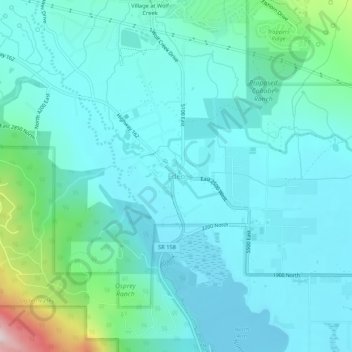
Название: Топографическая карта Eden, высота, рельеф.
Местонахождение: Eden, Weber County, Utah, 84310, United States (41.28447 -111.84630 41.32447 -111.80630)
Средняя высота: 1 562 м
Минимальная высота: 1 484 м
Максимальная высота: 1 964 м
Сделать пожертвование
Другие топографические карты
Нажмите на карту, чтобы просмотреть ее топографию, ее высоту и ее рельеф.
Ogden
United States > Utah > Weber County
According to the United States Census Bureau, the city has an area of 26.6 square miles (69.0 km2), all land. Elevations in the city range from about 4,300 to 5,000 feet (1,300 to 1,500 m) above sea level.
Средняя высота: 1 498 м
Ogden
United States > Utah > Weber County
According to the United States Census Bureau, the city has an area of 26.6 square miles (69.0 km2), all land. Elevations in the city range from about 4,300 to 5,000 feet (1,300 to 1,500 m) above sea level.
Средняя высота: 1 498 м
Сделать пожертвование
Ogden
United States > Utah > Weber County
According to the United States Census Bureau, the city has an area of 26.6 square miles (69 km2), all land. Elevations in the city range from about 4,300 to 5,000 feet (1,300 to 1,500 m) above sea level.
Средняя высота: 1 498 м
Сделать пожертвование
Сделать пожертвование
Сделать пожертвование
Ogden
United States > Utah > Weber County
According to the United States Census Bureau, the city has an area of 26.6 square miles (69.0 km2), all land. Elevations in the city range from about 4,300 to 5,000 feet (1,300 to 1,500 m) above sea level.
Средняя высота: 1 498 м
Сделать пожертвование