
Сделать пожертвование
Топографическая карта Jinan
Нажмите на карту, чтобы отобразить высоту.
Сделать пожертвование
Jinan
Due to the mountains to the south of the city, temperature inversions are common, occurring on about 200 days per year. The high precipitation for northern Chinese standards, in tandem with the topography (mountains surrounding the city on three sides), leads to particularly oppressive summer weather and the city being named as a candidate for the fourth "furnace", c.e. Three Furnaces. Extremes since 1951 have ranged from −19.7 °C (−3 °F) on January 17, 1953, to 42.5 °C (109 °F) on July 24, 1955.
Сделать пожертвование
Об этой карте
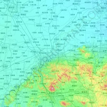
Название: Топографическая карта Jinan, высота, рельеф.
Местонахождение: Jinan, Shandong, China (35.99207 116.21932 37.53691 117.97263)
Средняя высота: 112 м
Минимальная высота: 6 м
Максимальная высота: 1 492 м
Сделать пожертвование
Другие топографические карты
Нажмите на карту, чтобы просмотреть ее топографию, ее высоту и ее рельеф.
Сделать пожертвование
Сделать пожертвование
Qingdao
Qingdao is located on the south facing coast of the Shandong Peninsula (German: Schantung Halbinsel). It borders three prefecture-level cities, namely Yantai to the northeast, Weifang to the west, and Rizhao to the southwest. The city's total jurisdiction area occupies 10,654 square kilometres (4,114 sq mi),…
Средняя высота: 25 м
Сделать пожертвование
Сделать пожертвование