Топографическая карта Sydney
Нажмите на карту, чтобы отобразить высоту.
Sydney
Sydney's topography is characterized by a diverse landscape that seamlessly blends coastal features with inland plateaus. The city is divided into two primary regions: the relatively flat Cumberland Plain to the south and west of Sydney Harbour, and the elevated Hornsby Plateau to the north. The Cumberland Plain, situated on Triassic shales and sandstones, features low rolling hills and wide valleys, with elevations typically ranging from 50 to 100 meters (164 to 328 feet) above sea level. In contrast, the Hornsby Plateau, composed of sandstone, rises to approximately 200 meters (656 feet) and is dissected by steep valleys, creating a rugged terrain with significant elevation changes. This varied topography contributes to Sydney's distinctive landscapes, including its iconic beaches, harbors, and natural parks.
Об этой карте
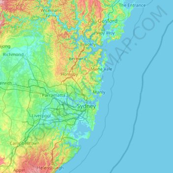
Название: Топографическая карта Sydney, высота, рельеф.
Местонахождение: Sydney, Council of the City of Sydney, New South Wales, Australia (-34.17324 150.26083 -33.36419 151.34390)
Средняя высота: 53 м
Минимальная высота: -3 м
Максимальная высота: 449 м
Другие топографические карты
Нажмите на карту, чтобы просмотреть ее топографию, ее высоту и ее рельеф.
Sydney
Phillip had been given no instructions for urban development, but in July 1788 submitted a plan for the new town at Sydney Cove. It included a wide central avenue, a permanent Government House, law courts, hospital and other public buildings, but no provision for warehouses, shops, or other commercial…
Средняя высота: 32 м
Mount Kosciuszko
Mount Kosciuszko is the highest summit in mainland Australia. Until 1977 it was possible to drive from Charlotte Pass to within a few metres of the summit, but in 1977 the road was closed to public motor vehicle access due to environmental concerns. The road is open from Charlotte Pass for walkers and cyclists…
Средняя высота: 2 035 м










Australian Alps
The Australian Alps are a mountain range in southeast Australia. It comprises an interim Australian bioregion, and is the highest mountain range in Australia. The range straddles the borders of eastern Victoria, southeastern New South Wales, and the Australian Capital Territory. It contains Australia's only…
Средняя высота: 2 037 м




Gaanha-bula–Mount Canobolas
With an elevation of 1,390 metres (4,560 ft) above sea level, Mount Canobolas, an extinct volcano, is the highest mountain in the region. Situated 13 kilometres (8.1 mi) southwest of the city of Orange, it is about 250 kilometres (155 mi) west of Sydney.
Средняя высота: 1 186 м




Blue Mountains
A sandstone plateau dominated by a landscape of endless eucalyptus forests, the Blue Mountains are located at the top of a 470-million-year-old quartzite. In the Permian period, a shallow sea covered the region, when rivers brought shales, siltstones and mudstones. Then during the Mesozoic period, rivers…
Средняя высота: 566 м




Nielsen Park
Australia > New South Wales > Sydney
As is common in all coastal and estuarine areas of the Sydney Region, the Park contains many rock outcrops, particularly along the foreshore headlands. These are given some added interest by the remnants of the effect of a basalt dyke that runs from Mount Trefle to Bottle and Glass Point resulting in the…
Средняя высота: 14 м

Mount Twynam
With an elevation of 2,195 metres (7,201 ft) above sea level, Mount Twynam is the 3rd-highest mountain on mainland Australia. It is located 8 kilometres (5.0 mi) north-east of Mount Kosciuszko.
Средняя высота: 1 992 м