
Топографическая карта Hot Springs National Park
Интерактивная карта
Нажмите на карту, чтобы отобразить высоту.
Об этой карте
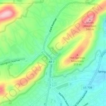
Название: Топографическая карта Hot Springs National Park, высота, рельеф.
Местонахождение: Hot Springs National Park, Hot Springs, Garland County, Arkansas, 71901, United States (34.51797 -93.05299 34.51807 -93.05289)
Средняя высота: 227 м
Минимальная высота: 158 м
Максимальная высота: 346 м
The National Park Service exercises no control or supervision over any matters connected with the city. The city starts on the other side of Central Avenue from Bathhouse Row. Its development has extended beyond the narrow valley in which the springs are located, spreading out over the open plain to the south and east. The climate is good throughout the year. The elevation of the city is 600 feet (180 m) above sea level, with surrounding hills rising another 600 feet. In the first half of the 20th century, the city operated primarily as a summer resort, but hotels have now long stayed open during the winter due to many northerly patrons coming to escape the winter cold.
Другие топографические карты
Нажмите на карту, чтобы просмотреть ее топографию, ее высоту и ее рельеф.
Piney
United States > Arkansas > Garland County > Hot Springs
Piney, Hot Springs, Garland County, Arkansas, United States
Средняя высота: 146 м
Lake Hamilton
United States > Arkansas > Garland County > Hot Springs
Lake Hamilton, Hot Springs, Garland County, Arkansas, United States
Средняя высота: 130 м
Hot Springs
United States > Arkansas > Garland County > Hot Springs
Hot Springs, Garland County, Arkansas, 71901, United States
Средняя высота: 187 м