
Топографическая карта Shercock
Интерактивная карта
Нажмите на карту, чтобы отобразить высоту.
Об этой карте
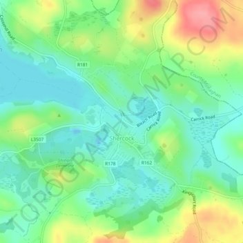
Название: Топографическая карта Shercock, высота, рельеф.
Местонахождение: Shercock, Shercock ED, Bailieborough-Cootehill Municipal District, County Cavan, Ulster, A81 DK60, Ireland (53.99053 -6.91070 54.00334 -6.88822)
Средняя высота: 117 м
Минимальная высота: 85 м
Максимальная высота: 176 м
The region is known as "Drumlin Country" owing to its topography of small hills and lakes formed at the end of the last ice age. County Cavan borders County Fermanagh and County Monaghan. Together, they form the colloquially named "Drumlin County". Shercock lies on the border between County Cavan and County Monaghan.
Другие топографические карты
Нажмите на карту, чтобы просмотреть ее топографию, ее высоту и ее рельеф.
Kilnaleck
Kilnaleck, Ballyjamesduff Municipal District, County Cavan, A82 X567, Ireland
Средняя высота: 114 м
Callanagh Lower
Callanagh Lower, Drumlumman ED, Ballyjamesduff Municipal District, County Cavan, Ulster, Ireland
Средняя высота: 85 м
Virginia
Virginia, Virginia ED, Ballyjamesduff Municipal District, County Cavan, Ireland
Средняя высота: 98 м
Crossdoney
Crossdoney, Ballyjamesduff Municipal District, County Cavan, H12 K727, Ireland
Средняя высота: 67 м
Bailieborough
Bailieborough, Bailieborough ED, Bailieborough-Cootehill Municipal District, County Cavan, A82 NX86, Ireland
Средняя высота: 162 м
Mount Nugent
Mount Nugent, Ballyjamesduff Municipal District, County Cavan, Ulster, Ireland
Средняя высота: 74 м
Ballyjamesduff
Ballyjamesduff, Ballyjamesduff Municipal District, County Cavan, Ulster, A82 CT95, Ireland
Средняя высота: 118 м
Ballyconnell
Ballyconnell, Ballyconnell ED, Cavan-Belturbet Municipal District, County Cavan, Ulster, H14 EC99, Ireland
Средняя высота: 68 м
Cootehill
Cootehill, Bailieborough-Cootehill Municipal District, County Cavan, Ulster, Ireland
Средняя высота: 89 м
Cornafean
Cornafean, Ballyjamesduff Municipal District, County Cavan, Ulster, Ireland
Средняя высота: 82 м
Killashandra
Killashandra, Killashandra ED, Cavan-Belturbet Municipal District, County Cavan, Ulster, Ireland
Средняя высота: 62 м
Loch Gowna (Scrabby)
Loch Gowna (Scrabby), Scrabby ED, Ballyjamesduff Municipal District, County Cavan, Ulster, Ireland
Средняя высота: 80 м
Snugborough
Snugborough, Ballyconnell ED, Cavan-Belturbet Municipal District, County Cavan, Ulster, Ireland
Средняя высота: 174 м
Tullycoe
Tullycoe, Larah North ED, Bailieborough-Cootehill Municipal District, County Cavan, Ulster, Ireland
Средняя высота: 96 м
Togher or Danesfort Demesne
Togher or Danesfort Demesne, Killykeen ED, Cavan-Belturbet Municipal District, County Cavan, Ulster, Ireland
Средняя высота: 64 м
Corfad
Corfad, Stradone ED, Bailieborough-Cootehill Municipal District, County Cavan, Ireland
Средняя высота: 130 м
Lisdaran
Lisdaran, Cavan Rural ED, Cavan-Belturbet Municipal District, County Cavan, Ulster, Ireland
Средняя высота: 73 м
Cormeen
Cormeen, Larah South ED, Bailieborough-Cootehill Municipal District, County Cavan, Ulster, Ireland
Средняя высота: 133 м
Monaghanoose
Monaghanoose, Drumanespick ED, Bailieborough-Cootehill Municipal District, County Cavan, Ireland
Средняя высота: 140 м
Bailieborough
Bailieborough, Bailieborough-Cootehill Municipal District, County Cavan, Ulster, A82 NX86, Ireland
Средняя высота: 163 м
Cleffin
Cleffin, Killinkere ED, Bailieborough-Cootehill Municipal District, County Cavan, Ulster, Ireland
Средняя высота: 128 м
Bailieborough
Ireland > County Cavan > Bailieborough
Bailieborough, Bailieborough-Cootehill Municipal District, County Cavan, A82 NX86, Ireland
Средняя высота: 169 м
Seefin
Seefin, Drumanespick ED, Bailieborough-Cootehill Municipal District, County Cavan, Ireland
Средняя высота: 194 м
Kilnavert
Kilnavert, Ballymagauran ED, Cavan-Belturbet Municipal District, County Cavan, Ireland
Средняя высота: 68 м
Killaghaduff
Killaghaduff, Swanlinbar ED, Cavan-Belturbet Municipal District, County Cavan, Ireland
Средняя высота: 91 м
Drumgart
Drumgart, Ardue ED, Cavan-Belturbet Municipal District, County Cavan, Ireland
Средняя высота: 55 м
Cornamucklagh
Ireland > County Cavan > Cornamucklagh
Cornamucklagh, Crossdoney ED, Ballyjamesduff Municipal District, County Cavan, H12K727, Ireland
Средняя высота: 61 м
Bailieborough-Cootehill Municipal District
Bailieborough-Cootehill Municipal District, County Cavan, Ulster, Ireland
Средняя высота: 122 м
Carrickallen
Carrickallen, Larah North ED, Bailieborough-Cootehill Municipal District, County Cavan, Ireland
Средняя высота: 185 м
Dunaree
Dunaree, Kingscourt ED, Bailieborough-Cootehill Municipal District, County Cavan, Ireland
Средняя высота: 115 м
Laraweehan
Laraweehan, Knappagh ED, Bailieborough-Cootehill Municipal District, County Cavan, Ireland
Средняя высота: 104 м
Drumlane
Drumlane, Drung ED, Bailieborough-Cootehill Municipal District, County Cavan, Ireland
Средняя высота: 93 м
Cavan-Belturbet Municipal District
Cavan-Belturbet Municipal District, County Cavan, Ulster, Ireland
Средняя высота: 111 м
Glangevlin
Glangevlin, Cavan-Belturbet Municipal District, County Cavan, Ulster, Ireland
Средняя высота: 185 м
Kilcogy
Kilcogy, Ballyjamesduff Municipal District, County Cavan, Ulster, Ireland
Средняя высота: 89 м