
Сделать пожертвование
Топографическая карта Plano
Нажмите на карту, чтобы отобразить высоту.
Сделать пожертвование
Plano
At first, Plano's population grew slowly, reaching 1,304 in 1900 and 3,695 in 1960. By 1970, Plano began to feel some of the boom its neighbors had experienced after World War II. A series of public works projects and a change in taxes that removed the farming community from the town helped increase the population. In 1970, the population reached 17,872, and by 1980, it had exploded to 72,000. Sewers, schools, and street development kept pace with this massive increase, largely because of Plano's flat topography, grid layout, and planning initiatives.
Сделать пожертвование
Об этой карте
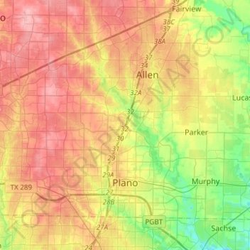
Название: Топографическая карта Plano, высота, рельеф.
Местонахождение: Plano, Collin County, Texas, United States (32.99705 -96.85997 33.12520 -96.61292)
Средняя высота: 196 м
Минимальная высота: 143 м
Максимальная высота: 244 м
Сделать пожертвование
Другие топографические карты
Нажмите на карту, чтобы просмотреть ее топографию, ее высоту и ее рельеф.
Сделать пожертвование
Frisco
United States > Texas > Collin County > Frisco
When the Dallas area was being settled by American pioneers, many of the settlers traveled by wagon trains along the Shawnee Trail. This trail became the Preston Trail, and later, Preston Road. With all of this activity, the community of Lebanon was founded along this trail, and was granted a U.S. post office…
Средняя высота: 191 м
Сделать пожертвование
Сделать пожертвование
Plano
United States > Texas > Collin County > Plano
At first, Plano's population grew slowly, reaching 1,304 in 1900 and 3,695 in 1960. By 1970, Plano began to feel some of the boom its neighbors had experienced after World War II. A series of public works projects and a change in taxes that removed the farming community from the town helped increase the…
Средняя высота: 181 м