
Сделать пожертвование
Топографическая карта Little Sturgeon
Нажмите на карту, чтобы отобразить высоту.
Сделать пожертвование
Об этой карте
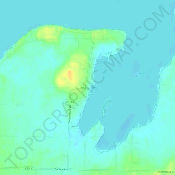
Название: Топографическая карта Little Sturgeon, высота, рельеф.
Местонахождение: Little Sturgeon, Town of Gardner, Door County, Wisconsin, United States (44.81888 -87.58260 44.85888 -87.54260)
Средняя высота: 179 м
Минимальная высота: 173 м
Максимальная высота: 201 м
Сделать пожертвование
Другие топографические карты
Нажмите на карту, чтобы просмотреть ее топографию, ее высоту и ее рельеф.
Sturgeon Bay
United States > Wisconsin > Door County
Stevens Hill is a populated place within the city of Sturgeon Bay, just to the northeast of the downtown. The top of the hill has the highest elevation in the city. It is within Big Hill Park, which is 13.2 acres in area and is used for mountain biking, picnicking, and sledding.
Средняя высота: 199 м
Сделать пожертвование