
Сделать пожертвование
Топографическая карта Coachella
Нажмите на карту, чтобы отобразить высоту.
Сделать пожертвование
Coachella
The elevation is 68 feet (21 m) below sea level, as the eastern half of the Coachella Valley is below sea level. The saltwater lake, Salton Sea, 10 miles (16 km) south of Coachella, is 228 feet (69 m) below sea level.
Сделать пожертвование
Об этой карте
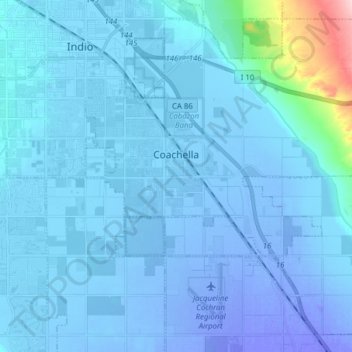
Название: Топографическая карта Coachella, высота, рельеф.
Местонахождение: Coachella, Riverside County, California, 92236, United States (33.61312 -116.21649 33.72953 -116.06063)
Средняя высота: -2 м
Минимальная высота: -48 м
Максимальная высота: 234 м
Сделать пожертвование
Другие топографические карты
Нажмите на карту, чтобы просмотреть ее топографию, ее высоту и ее рельеф.
Colorado River
United States > California > Riverside County
The entire eastern boundary of the Colorado River Basin runs along the North American Continental Divide and is defined largely by the Rocky Mountains and the Rio Grande Basin. The Wind River Range in Wyoming marks the northern extent of the basin, and is separated from the Colorado Rockies by the endorheic…
Средняя высота: 93 м
Idyllwild-Pine Cove
United States > California > Riverside County
"Mile-high Idyllwild" is a mountain resort about one-mile (1,600 m) in altitude. Idyllwild is flanked by two large rock formations, Tahquitz Peak and Suicide Rock (also known as Lily Rock), which are famous in Southern California rock-climbing circles. It offers no skiing, so "the Hill" has been minimally…
Средняя высота: 1 746 м
Сделать пожертвование