
Топографическая карта Rudge
Нажмите на карту, чтобы отобразить высоту.
Об этой карте
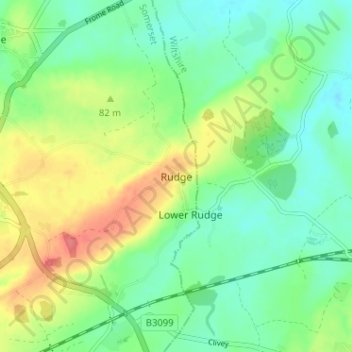
Название: Топографическая карта Rudge, высота, рельеф.
Местонахождение: Rudge, Somerset, England, BA11 2QG, United Kingdom (51.24887 -2.26859 51.28887 -2.22859)
Средняя высота: 69 м
Минимальная высота: 45 м
Максимальная высота: 110 м
Другие топографические карты
Нажмите на карту, чтобы просмотреть ее топографию, ее высоту и ее рельеф.
Mells Park
United Kingdom > England > Somerset > Vobster
The architect Edwin Lutyens had known the Horners, and Mells Park, since 1896. In 1918 he unsuccessfully tried to persuade the Horners to rebuild Park House. However, Reginald McKenna, the chairman of Midland Bank, and formerly Home Secretary and Chancellor of the Exchequer under Asquith, was married to Pamela…
Средняя высота: 134 м
Quantock Hills National Landscape
United Kingdom > England > Somerset > Over Stowey
Средняя высота: 116 м
Priddy
United Kingdom > England > Somerset
The village lies in a small hollow near the summit of the Mendip range of hills, at an elevation of nearly 1,000 feet (300 m) above sea-level, and has evidence of occupation since neolithic times. There are remains of lead mining activities and caves in the limestone beneath the village.
Средняя высота: 206 м
Muchelney
United Kingdom > England > Somerset
Muchelney (/ˈmʌtʃəlni/) is a clustered village and civil parish in Somerset, England, extending for 3 kilometres (1.9 mi) from the south bank of the River Parrett and that has a clustered centre. This is 1 mile (1.6 km) south of Huish and Langport and 4 miles (6.4 km) south west of Somerton in the South…
Средняя высота: 9 м