
Топографическая карта Donagh
Интерактивная карта
Нажмите на карту, чтобы отобразить высоту.
Об этой карте
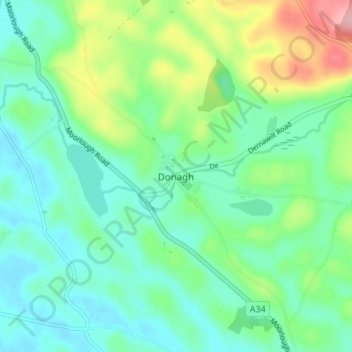
Название: Топографическая карта Donagh, высота, рельеф.
Местонахождение: Donagh, County Fermanagh, Northern Ireland, BT92 5BG, United Kingdom (54.19665 -7.41099 54.23665 -7.37099)
Средняя высота: 82 м
Минимальная высота: 44 м
Максимальная высота: 181 м
Другие топографические карты
Нажмите на карту, чтобы просмотреть ее топографию, ее высоту и ее рельеф.
Brookeborough
United Kingdom > Northern Ireland > County Fermanagh
Brookeborough, County Fermanagh, Northern Ireland, BT94 4EZ, United Kingdom
Средняя высота: 97 м
Brattan's Hill
United Kingdom > Northern Ireland > County Fermanagh
Brattan's Hill, Ardunshin, County Fermanagh, Northern Ireland, BT94 4RT, United Kingdom
Средняя высота: 79 м
White Island
United Kingdom > Northern Ireland > County Fermanagh
White Island, County Fermanagh, Ulster, Northern Ireland, United Kingdom
Средняя высота: 48 м
Lough Navar
United Kingdom > Northern Ireland > County Fermanagh
Lough Navar, Barr of Drumbadmeen, County Fermanagh, Ulster, Northern Ireland, United Kingdom
Средняя высота: 232 м
Carr
United Kingdom > Northern Ireland > County Fermanagh
Carr, County Fermanagh, Northern Ireland, United Kingdom
Средняя высота: 60 м
Tempo
United Kingdom > Northern Ireland > County Fermanagh > Tempo
Tempo, County Fermanagh, Northern Ireland, BT94 3LU, United Kingdom
Средняя высота: 127 м
Bellanaleck
United Kingdom > Northern Ireland > County Fermanagh
Bellanaleck, County Fermanagh, Ulster, Northern Ireland, BT92 2BA, United Kingdom
Средняя высота: 54 м
Irvinestown
United Kingdom > Northern Ireland > County Fermanagh
Irvinestown, County Fermanagh, Ulster, Northern Ireland, BT94 1GS, United Kingdom
Средняя высота: 95 м
Belcoo
United Kingdom > Northern Ireland > County Fermanagh
Belcoo, County Fermanagh, Ulster, Northern Ireland, BT93 5FB, United Kingdom
Средняя высота: 86 м
Derrygonnelly
United Kingdom > Northern Ireland > County Fermanagh
Derrygonnelly, County Fermanagh, Ulster, Northern Ireland, BT93 6HW, United Kingdom
Средняя высота: 79 м