
Топографическая карта Burton-on-Trent
Интерактивная карта
Нажмите на карту, чтобы отобразить высоту.
Об этой карте
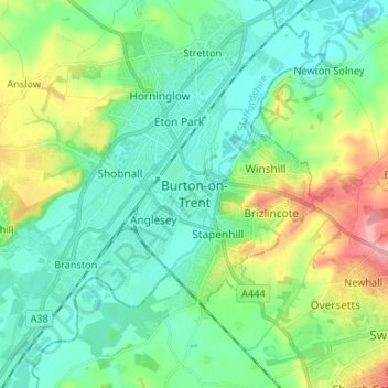
Название: Топографическая карта Burton-on-Trent, высота, рельеф.
Местонахождение: Burton-on-Trent, East Staffordshire, Staffordshire, England, DE14 1JN, United Kingdom (52.76274 -1.66992 52.84274 -1.58992)
Средняя высота: 69 м
Минимальная высота: 38 м
Максимальная высота: 149 м
Burton is about 109 miles (175 km) north west of London, about 30 miles north east of Birmingham, the UK's second largest city and about 23 miles east of the county town Stafford. It is at the easternmost border of the county of Staffordshire with Derbyshire, its suburbs and the course of the River Trent forming part of the county boundary. It is also near the south-eastern terminus of the Trent and Mersey Canal. Burton lies within the northern boundary of the National Forest. The town centre is on the western bank of the River Trent in a valley bottom; its average elevation is about 50 metres above sea level; the village of Winshill and the suburb of Stapenhill rise to 130 m and 100 m respectively.
Другие топографические карты
Нажмите на карту, чтобы просмотреть ее топографию, ее высоту и ее рельеф.
Stretton
United Kingdom > England > Staffordshire > East Staffordshire
Stretton, East Staffordshire, Staffordshire, England, DE13 0FE, United Kingdom
Средняя высота: 55 м
Gratwich
United Kingdom > England > Staffordshire > East Staffordshire > Kingstone
Gratwich, Kingstone, East Staffordshire, Staffordshire, England, ST14 8WE, United Kingdom
Средняя высота: 143 м
Fauld
United Kingdom > England > Staffordshire > East Staffordshire > Hanbury
Fauld, Hanbury, East Staffordshire, Staffordshire, England, DE13 9HT, United Kingdom
Средняя высота: 88 м
Stanton
United Kingdom > England > Staffordshire > East Staffordshire
Stanton, East Staffordshire, Staffordshire, England, DE6 2DA, United Kingdom
Средняя высота: 222 м
Birch Cross
United Kingdom > England > Staffordshire > East Staffordshire > Marchington
Birch Cross, Marchington, East Staffordshire, Staffordshire, England, ST14 8NX, United Kingdom
Средняя высота: 92 м
Stubwood
United Kingdom > England > Staffordshire > East Staffordshire > Denstone
Stubwood, Denstone, East Staffordshire, Staffordshire, England, ST14 5HX, United Kingdom
Средняя высота: 113 м
Denstone
United Kingdom > England > Staffordshire > East Staffordshire
Denstone, East Staffordshire, Staffordshire, England, United Kingdom
Средняя высота: 121 м
Tutbury Castle
United Kingdom > England > Staffordshire > East Staffordshire > Tutbury
Tutbury Castle, Castle Street, Tutbury, East Staffordshire, Staffordshire, England, DE13 9JF, United Kingdom
Средняя высота: 66 м
Shobnall
United Kingdom > England > Staffordshire > East Staffordshire > Burton-on-Trent
Shobnall, Burton-on-Trent, East Staffordshire, Staffordshire, England, United Kingdom
Средняя высота: 56 м
Harlow Wood
United Kingdom > England > Staffordshire > East Staffordshire > Upper Mayfield
Harlow Wood, Stanton, Upper Mayfield, East Staffordshire, Staffordshire, England, United Kingdom
Средняя высота: 177 м
Draycott in the Clay
United Kingdom > England > Staffordshire > East Staffordshire > Draycott in the Clay
Draycott in the Clay, East Staffordshire, Staffordshire, West Midlands, England, United Kingdom
Средняя высота: 90 м
Rolleston on Dove
United Kingdom > England > Staffordshire > East Staffordshire
Rolleston on Dove, East Staffordshire, Staffordshire, England, United Kingdom
Средняя высота: 61 м
Tutbury
United Kingdom > England > Staffordshire > East Staffordshire
Tutbury, East Staffordshire, Staffordshire, England, United Kingdom
Средняя высота: 80 м
Bramshall
United Kingdom > England > Staffordshire > East Staffordshire > Bramshall
Bramshall, East Staffordshire, Staffordshire, West Midlands, England, ST14 5DE, United Kingdom
Средняя высота: 121 м
Hanbury
United Kingdom > England > Staffordshire > East Staffordshire
Hanbury, East Staffordshire, Staffordshire, England, United Kingdom
Средняя высота: 107 м
Blithfield Reservoir
United Kingdom > England > Staffordshire > East Staffordshire > Admaston
Blithfield Reservoir, Admaston, East Staffordshire, Staffordshire, West Midlands, England, United Kingdom
Средняя высота: 108 м
Yoxall
United Kingdom > England > Staffordshire > East Staffordshire > Yoxall
Yoxall, East Staffordshire, Staffordshire, West Midlands, England, United Kingdom
Средняя высота: 89 м
Hoar Cross
United Kingdom > England > Staffordshire > East Staffordshire > Hoar Cross
Hoar Cross, East Staffordshire, Staffordshire, West Midlands, England, United Kingdom
Средняя высота: 110 м
Barton-under-Needwood
United Kingdom > England > Staffordshire > East Staffordshire
Barton-under-Needwood, East Staffordshire, Staffordshire, England, United Kingdom
Средняя высота: 69 м
Abbots Bromley
United Kingdom > England > Staffordshire > East Staffordshire
Abbots Bromley, East Staffordshire, Staffordshire, England, United Kingdom
Средняя высота: 114 м
Uttoxeter
United Kingdom > England > Staffordshire > East Staffordshire
Uttoxeter, East Staffordshire, Staffordshire, England, United Kingdom
Средняя высота: 100 м
Rocester
United Kingdom > England > Staffordshire > East Staffordshire
Rocester, East Staffordshire, Staffordshire, England, United Kingdom
Средняя высота: 105 м
Stapenhill
United Kingdom > England > Staffordshire > East Staffordshire
Stapenhill, East Staffordshire, Staffordshire, England, United Kingdom
Средняя высота: 67 м
Ellastone
United Kingdom > England > Staffordshire > East Staffordshire
Ellastone, East Staffordshire, Staffordshire, England, DE6 2GZ, United Kingdom
Средняя высота: 141 м
Anslow
United Kingdom > England > Staffordshire > East Staffordshire
Anslow, East Staffordshire, Staffordshire, England, United Kingdom
Средняя высота: 88 м
Croxden
United Kingdom > England > Staffordshire > East Staffordshire
Croxden, East Staffordshire, Staffordshire, England, United Kingdom
Средняя высота: 137 м