Топографическая карта Delicate Arch
Интерактивная карта
Нажмите на карту, чтобы отобразить высоту.
Об этой карте
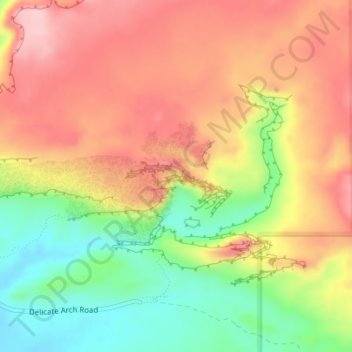
Название: Топографическая карта Delicate Arch, высота, рельеф.
Местонахождение: Delicate Arch, Delicate Arch Trail, Grand County, Utah, United States (38.74341 -109.49945 38.74353 -109.49913)
Средняя высота: 1 409 м
Минимальная высота: 1 309 м
Максимальная высота: 1 490 м
Delicate Arch is one of the main tourist draws in Arches National Park. The parking lot at the Delicate Arch Trailhead, although large, fills up quickly on most days. The trail to Delicate Arch is 3 miles (4.8 kilometer) round trip with an elevation change of 480 feet (146 meters). The trail is well defined for the first 1/2 mile, then does a steep incline over open rock. There is a narrow ledge for the last 200 yards (183 meter) before reaching the arch.
Другие топографические карты
Нажмите на карту, чтобы просмотреть ее топографию, ее высоту и ее рельеф.
Moab
United States > Utah > Grand County
Moab, Grand County, Utah, 84532, United States
Средняя высота: 1 357 м
Westwater
United States > Utah > Grand County
Westwater, Grand County, Utah, United States
Средняя высота: 1 349 м
Cisco
United States > Utah > Grand County
Cisco, Grand County, Utah, 84515, United States
Средняя высота: 1 334 м
Rectory
United States > Utah > Grand County
Rectory, Grand County, Utah, United States
Средняя высота: 1 527 м
Arches National Park
United States > Utah > Grand County
Arches National Park, Grand County, Utah, United States
Средняя высота: 1 476 м
Thompson Springs
United States > Utah > Grand County
Thompson Springs, Grand County, Utah, 84540, United States
Средняя высота: 1 583 м
Colorado River
United States > Utah > Grand County > Moab
Colorado River, Moab, Grand County, Utah, United States
Средняя высота: 1 668 м
Castle Valley
United States > Utah > Grand County
Castle Valley, Grand County, Utah, United States
Средняя высота: 1 610 м
Cottonwood Point
United States > Utah > Grand County
Cottonwood Point, Grand County, Utah, United States
Средняя высота: 2 346 м
La Sal Mountains Viewpoint
United States > Utah > Grand County
La Sal Mountains Viewpoint, Main Park Road, Grand County, Utah, 84532-2134, United States
Средняя высота: 1 347 м