
Сделать пожертвование
Топографическая карта Coahuila
Нажмите на карту, чтобы отобразить высоту.
Сделать пожертвование
Coahuila
The Sierra Madre Oriental runs northwest to southeast through the State, and the higher elevations are home to the Sierra Madre Oriental pine-oak forests. The northernmost fingers of the Sierra Madre Oriental, the Sierra del Burro and the Sierra del Carmen, reach to the border with the United States at the Rio Grande.
Сделать пожертвование
Об этой карте
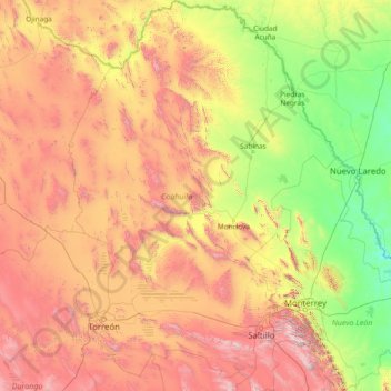
Название: Топографическая карта Coahuila, высота, рельеф.
Местонахождение: Coahuila, Mexico (24.54268 -103.96000 29.88003 -99.84288)
Средняя высота: 1 009 м
Минимальная высота: 61 м
Максимальная высота: 3 619 м
Сделать пожертвование
Другие топографические карты
Нажмите на карту, чтобы просмотреть ее топографию, ее высоту и ее рельеф.
Сделать пожертвование
Ciudad Juárez
Due to its location in the Chihuahuan Desert and high altitude, Ciudad Juárez has a cold desert climate (Köppen: BWk). Seasons are distinct, with hot summers, mild springs and autumns, and cold winters. Summer average high is 35 °C (95 °F) with lows of 21 °C (70 °F). Winter highs average 14 °C (57 °F)…
Средняя высота: 1 228 м
Сделать пожертвование
Сделать пожертвование
Acapulco
Mexico > Guerrero > Acapulco de Juárez
The city, located on the Pacific coast of Mexico in the state of Guerrero, is classified as one of the state's seven regions, dividing the rest of the Guerrero coast into the Costa Grande and the Costa Chica. Forty percent of the municipality is mountainous terrain; another forty percent is semi-flat; and the…
Средняя высота: 99 м
Сделать пожертвование
Villahermosa
Villahermosa is located in the southeast of Mexico between the rivers Grijalva and Carrizal. The average elevation of the city is 10 meters above sea level. The city also has several lagoons, the largest and most important of them being La Laguna de las Ilusiones (Illusions Lagoon).
Средняя высота: 9 м
Сделать пожертвование
Сделать пожертвование