
Сделать пожертвование
Топографическая карта Oswestry
Нажмите на карту, чтобы отобразить высоту.
Сделать пожертвование
Об этой карте
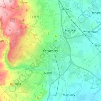
Название: Топографическая карта Oswestry, высота, рельеф.
Местонахождение: Oswestry, Shropshire, England, SY11 1PX, United Kingdom (52.82031 -3.09482 52.90031 -3.01482)
Средняя высота: 158 м
Минимальная высота: 74 м
Максимальная высота: 381 м
Сделать пожертвование
Другие топографические карты
Нажмите на карту, чтобы просмотреть ее топографию, ее высоту и ее рельеф.
Ludlow
United Kingdom > England > Shropshire
During the 12th century, the planned town of Ludlow was formed, in stages, the town providing a useful source of income for successive Marcher Lords, based on rents, fines, and tolls. They developed the town on a regular grid pattern, although this was adapted somewhat to match the local topography, from the…
Средняя высота: 108 м
Shrewsbury
United Kingdom > England > Shropshire
The town centre is partially built on a hill whose elevation is, at its highest, 246 feet (75 m) above sea level. The longest river in the United Kingdom, the River Severn, flows through the town, forming a meander around its centre. The Rea Brook is a small river that has its confluence with the Severn at…
Средняя высота: 69 м