
Сделать пожертвование
Топографическая карта West Jordan
Нажмите на карту, чтобы отобразить высоту.
Сделать пожертвование
West Jordan
West Jordan is a city in Salt Lake County, Utah, United States. It is a suburb of Salt Lake City. According to the 2020 Census, the city had a population of 116,961, placing it as the third most populous in the state. The city occupies the southwest end of the Salt Lake Valley at an elevation of 4,330 feet (1,320 m). Named after the nearby Jordan River, the limits of the city begin on the river's western bank and end in the eastern foothills of the Oquirrh Mountains, where Kennecott Copper Mine, the world's largest man-made excavation, is located.
Сделать пожертвование
Об этой карте
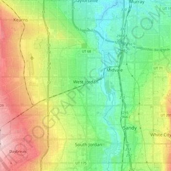
Название: Топографическая карта West Jordan, высота, рельеф.
Местонахождение: West Jordan, Salt Lake County, Utah, United States (40.56594 -112.08259 40.64014 -111.91174)
Средняя высота: 1 372 м
Минимальная высота: 1 296 м
Максимальная высота: 1 507 м
Сделать пожертвование
Другие топографические карты
Нажмите на карту, чтобы просмотреть ее топографию, ее высоту и ее рельеф.
Salt Lake City
United States > Utah > Salt Lake County > Salt Lake City
Salt Lake City has an area of 110.4 square miles (286 km2) and an average elevation of 4,327 feet (1,319 m) above sea level. The lowest point within the boundaries of the city is 4,210 feet (1,280 m) near the Jordan River and the Great Salt Lake, and the highest is Grandview Peak, at 9,410 feet (2,868 m).
Средняя высота: 1 625 м
Сделать пожертвование