
Сделать пожертвование
Топографическая карта Abraham Lake
Нажмите на карту, чтобы отобразить высоту.
Сделать пожертвование
Abraham Lake
The Government of Alberta sponsored a contest to name the lake in February 1972, during the final stages of construction of the Bighorn Dam. Students across the province were asked to submit names taking into consideration "historical significance, prominent persons, geography and topography, and the value of the lake." It was eventually named after Silas Abraham (c. 1870–1964), of the Stoney Nakoda First Nation and originally from Morley, Alberta. He was a farmer and hunter who lived in the Kootenay Plains and later on the Big Horn 144A reserve.
Сделать пожертвование
Об этой карте
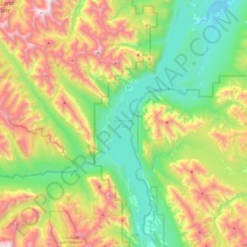
Название: Топографическая карта Abraham Lake, высота, рельеф.
Местонахождение: Abraham Lake, Census Division No. 9, Alberta, Canada (52.07360 -116.48898 52.33277 -116.32587)
Средняя высота: 1 886 м
Минимальная высота: 1 222 м
Максимальная высота: 3 095 м
Сделать пожертвование
Другие топографические карты
Нажмите на карту, чтобы просмотреть ее топографию, ее высоту и ее рельеф.
Moutain Vew Park
Canada > Alberta > Census Division No. 9 > Rocky Mountain House
Средняя высота: 978 м