
Сделать пожертвование
Топографическая карта Thailand
Нажмите на карту, чтобы отобразить высоту.
Сделать пожертвование
Об этой карте
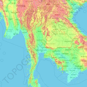
Название: Топографическая карта Thailand, высота, рельеф.
Местонахождение: Thailand (7.89719 93.83273 21.89719 107.83273)
Средняя высота: 235 м
Минимальная высота: -3 м
Максимальная высота: 2 908 м
Сделать пожертвование
Другие топографические карты
Нажмите на карту, чтобы просмотреть ее топографию, ее высоту и ее рельеф.
Kanchanaburi Province
The province is in the west of Thailand, 129 km from Bangkok, and covers a total area of approximately 19,483 km2 (7,522 sq mi). It is the country's third largest province, after Nakhon Ratchasima and Chiang Mai. Topographically, it is covered with timber and evergreen forests. The total forest area is 12,002…
Средняя высота: 297 м
Сделать пожертвование
Chiang Mai Province
Chiang Mai province is about 685 km (426 mi) from Bangkok in the Mae Ping River basin and is on average at 300 m (1,000 ft) elevation. Surrounded by the mountain ranges of the Thai highlands, it covers an area of approximately 22,135 km2 (9,000 sq mi). The mountains of the Daen Lao Range…
Средняя высота: 649 м
Сделать пожертвование
Chanthaburi Province
While the southern part of the province is on the shore of the Gulf of Thailand and thus is mostly coastal alluvial plains, the interior of the province is mountainous. The Chanthaburi Mountains in the north has the highest elevation in the province, the 1,675 m high Khao Soi Dao Tai peak. The main river of…
Средняя высота: 96 м
Сделать пожертвование
Phuket Province
Although some recent geographical works refer to the sections of the Tenasserim Hills in the isthmus as the "Phuket Range", these names are not found in classical geographic sources. Besides, the name Phuket is relatively recent having previously been named Jung Ceylon and Thalang. The highest elevation of the…
Средняя высота: 5 м
Сделать пожертвование
Nonthaburi City Municipality
Thailand > Nonthaburi Province > Mueang Nonthaburi District > Nonthaburi City Municipality
Средняя высота: 5 м
Maha Phram Subdistrict Municipality
Thailand > Phra Nakhon Si Ayutthaya Province > Bang Ban District
Средняя высота: 5 м