
Сделать пожертвование
Топографическая карта Hopa
Нажмите на карту, чтобы отобразить высоту.
Сделать пожертвование
Об этой карте
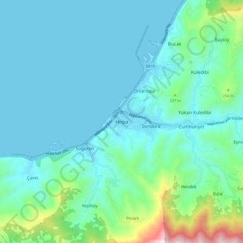
Название: Топографическая карта Hopa, высота, рельеф.
Местонахождение: Hopa, Artvin, Black Sea Region, 08600, Turkey (41.34875 41.37816 41.42875 41.45816)
Средняя высота: 168 м
Минимальная высота: 0 м
Максимальная высота: 1 060 м
Сделать пожертвование
Другие топографические карты
Нажмите на карту, чтобы просмотреть ее топографию, ее высоту и ее рельеф.
Taurus Mountains
The mountains have a Mediterranean climate, with dry summers and rainy winters. Temperatures vary with elevation, with warm winters on the lower coastal slopes and cold winters in the high mountains and in the interior.
Средняя высота: 828 м
Сделать пожертвование
Prince Islands
All islands contain hills, the highest being Büyükada's Aya Yorgi Hill with 203 meters of elevation.
Средняя высота: 12 м
Anatolia
Anatolia (Turkish: Anadolu), also known as Asia Minor, is a peninsula in West Asia that makes up the majority of the land area of Turkey. It is the westernmost protrusion of Asia and is geographically bounded by the Mediterranean Sea to the south, the Aegean Sea to the west, the Turkish Straits to the…
Средняя высота: 518 м
Сделать пожертвование
Сделать пожертвование
Сделать пожертвование
İzmit
The city is mostly built on hill slopes because of the cramped area, while flat plains surround the gulf, near the sea. This topographic structure divided the city into two parts. The first was created on flat plains, where the city center is located. The railway and highway networks pass from this area which…
Средняя высота: 194 м
Antalya
The highest point of the Taurus mountains is Akdağ at an altitude of 3025 metres. Located to the northwest of the city centre and at a distance of 50 km (31 mi) is the Saklıkent ski and recreation centre on Beydağları. Here one can ski and then go down to the shore and into the sea during the months of…
Средняя высота: 644 м
Сделать пожертвование
Сделать пожертвование
Kaş
As the tenth most populous district of Antalya as of 2022, Kaş is on a hill running down to the Turquoise Coast of southwestern Turkey. The district has a typical Mediterranean climate of hot, dry summers and mild, wet winters, which allows the growth of oranges, lemons and bananas. The lowland areas are also…
Средняя высота: 837 м
Сделать пожертвование
Сделать пожертвование
Сделать пожертвование
Сделать пожертвование
Sivas
The city, which lies at an elevation of 1,278 metres (4,193 ft) in the broad valley of the Kızılırmak river, is a moderately-sized trade centre and industrial city, although the economy has traditionally been based on agriculture. Rail repair shops and a thriving manufacturing industry of rugs, bricks,…
Средняя высота: 1 482 м
Сделать пожертвование
Kaş
As the tenth largest district of Antalya as of 2021, Kaş is on a hill running down to the Turquoise Coast of southwestern Turkey. The district has a typical Mediterranean climate of hot, dry summers and mild, wet winters, which allows the growth of oranges, lemons and bananas. The lowland areas are also…
Средняя высота: 837 м
Сделать пожертвование
Сделать пожертвование
Bağcılar
Bağcılar is located on the European side of Istanbul, within the service boundaries of Istanbul Metropolitan Municipality. Its area is 22 km2 (8.5 sq mi). The district is now known as an immigrant quarter. It lies between E-5 and TEM. In the south Bahçelievler, in the west Küçükçekmece, in the northwest…
Средняя высота: 85 м
Сделать пожертвование
Сделать пожертвование
Сделать пожертвование
Şereflikoçhisar
Şereflikoçhisar, formerly known as Koçhisar, is a municipality and district of Ankara Province, Turkey. Its area is 2,155 km2, and its population is 33,140 (2022). It is 148 km south of the city of Ankara. Its average elevation ranges between 900 and 1,200 m, with the highest point being Mt. Karasenir at…
Средняя высота: 1 009 м
Сделать пожертвование
Antakya
Antakya's climate is classified as hot-summer Mediterranean (Köppen: Csa) or dry-summer humid subtropical (Trewartha: Cf or wet Cs). The city experiences hot, dry summers, and mild, wet winters; though its higher altitude allows for lower temperatures than the coast.
Средняя высота: 385 м
Сделать пожертвование
Сделать пожертвование
Сделать пожертвование
Сделать пожертвование
Сделать пожертвование
Сделать пожертвование