
Топографическая карта Bristol
Интерактивная карта
Нажмите на карту, чтобы отобразить высоту.
Об этой карте
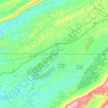
Название: Топографическая карта Bristol, высота, рельеф.
Местонахождение: Bristol, Sullivan County, Tennessee, 37625, United States (36.43450 -82.34852 36.75450 -82.02852)
Средняя высота: 579 м
Минимальная высота: 399 м
Максимальная высота: 1 310 м
Like much of the rest of the state, Bristol has a humid subtropical climate (Köppen climate classification: Cfa), although with significantly cooler temperatures, especially in the summer, due to elevation; it is part of USDA hardiness zone 6b, with areas to the southwest falling in zone 7a. The normal monthly mean temperature ranges from 35.2 °F (1.8 °C) in January to 74.6 °F (23.7 °C) in July, while, on average, 8.8 days have temperatures at or below freezing and 17 days with highs at or above 90 °F (32 °C) per year. The all-time record low is −21 °F (−29 °C), set on January 21, 1985, while the all-time record high is 103 °F (39 °C), set on June 30, 2012.