
Спасибо за поддержку этого сайта ❤️
Сделать пожертвование
Сделать пожертвование
Топографическая карта Amarnath Cave Temple
Нажмите на карту, чтобы отобразить высоту.
Спасибо за поддержку этого сайта ❤️
Сделать пожертвование
Сделать пожертвование
Amarnath Cave Temple
Amarnath Temple is a Hindu shrine located in the Pahalgam tehsil of the Anantnag district of Jammu and Kashmir, India. It is a cave situated at an altitude of 3,888 m (12,756 ft), about 168 km from Anantnag city, the district headquarters, 141 km (88 mi) from Srinagar, the summer capital of Jammu and Kashmir, reached through either Sonamarg or Pahalgam. It is an important shrine in Hinduism.
Спасибо за поддержку этого сайта ❤️
Сделать пожертвование
Сделать пожертвование
Об этой карте
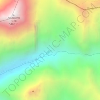
Название: Топографическая карта Amarnath Cave Temple, высота, рельеф.
Местонахождение: Amarnath Cave Temple, Amarnath, Pahalgam, Anantnag, Jammu and Kashmir, India (34.20564 75.49383 34.22564 75.51383)
Средняя высота: 4 325 м
Минимальная высота: 3 719 м
Максимальная высота: 5 200 м
Спасибо за поддержку этого сайта ❤️
Сделать пожертвование
Сделать пожертвование