
Топографическая карта Alpine
Интерактивная карта
Нажмите на карту, чтобы отобразить высоту.
Об этой карте
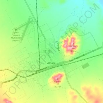
Название: Топографическая карта Alpine, высота, рельеф.
Местонахождение: Alpine, Brewster County, Texas, United States (30.34404 -103.70590 30.39172 -103.62556)
Средняя высота: 1 373 м
Минимальная высота: 1 305 м
Максимальная высота: 1 493 м
Alpine (/ˈælpaɪn/ AL-pyne) is a city in the county seat of Brewster County, Texas, United States. The population was 5,905 at the 2010 census. The town has an elevation of 4,475 feet (1,364 m), and the surrounding mountain peaks are over 1 mile (1.6 km) above sea level. The university, hospital, library, and retail make Alpine the center of the sprawling 12,000 square miles (3,108,000 ha) but wide open Big Bend area (combined population only 12,500) including Brewster, Presidio, and Jeff Davis counties.
Другие топографические карты
Нажмите на карту, чтобы просмотреть ее топографию, ее высоту и ее рельеф.
Terlingua
United States > Texas > Brewster County
Terlingua, Brewster County, Texas, United States
Средняя высота: 872 м
Alpine
United States > Texas > Brewster County
Alpine, Brewster County, Texas, United States
Средняя высота: 1 373 м
Big Bend National Park
United States > Texas > Brewster County
Big Bend National Park, Brewster County, Texas, 79834, United States
Средняя высота: 934 м
Big Bend National Park
United States > Texas > Brewster County
Big Bend National Park, Brewster County, Texas, 79834, United States
Средняя высота: 934 м
Horseshoe Mesa
United States > Texas > Brewster County
Horseshoe Mesa, Brewster County, Texas, United States
Средняя высота: 1 010 м
Marathon
United States > Texas > Brewster County
Marathon, Brewster County, Texas, 79842, United States
Средняя высота: 1 244 м
Cathedral Mountain
United States > Texas > Brewster County
Cathedral Mountain, Brewster County, Texas, United States
Средняя высота: 1 627 м
Santiago Peak
United States > Texas > Brewster County
Santiago Peak, Brewster County, Texas, United States
Средняя высота: 1 525 м
Dagger Mountain
United States > Texas > Brewster County
Dagger Mountain, Brewster County, Texas, United States
Средняя высота: 1 068 м
Lajitas
United States > Texas > Brewster County
Lajitas, Brewster County, Texas, United States
Средняя высота: 755 м
Emory Peak
United States > Texas > Brewster County
Emory Peak, Brewster County, Texas, United States
Средняя высота: 2 061 м