
Топографическая карта Gifford Pinchot National Forest
Интерактивная карта
Нажмите на карту, чтобы отобразить высоту.
Об этой карте
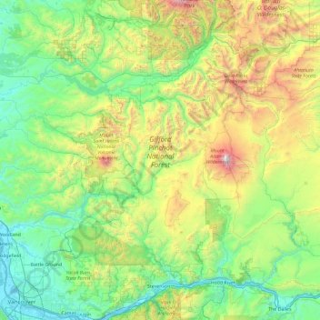
Название: Топографическая карта Gifford Pinchot National Forest, высота, рельеф.
Местонахождение: Gifford Pinchot National Forest, Skamania County, Washington, United States (45.55673 -122.49090 46.83507 -120.87891)
Средняя высота: 769 м
Минимальная высота: -1 м
Максимальная высота: 3 703 м
Gifford Pinchot National Forest is located in a mountainous region approximately between Mount St. Helens to the west, Mount Adams to the east, Mount Rainier National Park to the north, and the Columbia River to the south. This region of Southwest Washington is noted for its complex topography and volcanic geology. About 65 percent of the forest acreage is located in Skamania County. In descending order of land area the others are Lewis, Yakima, Cowlitz, and Klickitat counties.
Другие топографические карты
Нажмите на карту, чтобы просмотреть ее топографию, ее высоту и ее рельеф.
Mount Saint Helens
United States > Washington > Skamania County
Mount Saint Helens, Skamania County, Washington, United States
Средняя высота: 2 096 м
Spirit Lake
United States > Washington > Skamania County
Spirit Lake, Skamania County, Washington, United States
Средняя высота: 1 144 м