
Топографическая карта Les Navets
Интерактивная карта
Нажмите на карту, чтобы отобразить высоту.
Об этой карте
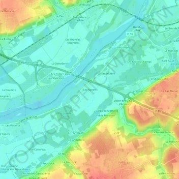
Название: Топографическая карта Les Navets, высота, рельеф.
Местонахождение: Les Navets, Villandry, Tours, Indre-et-Loire, Centre-Val de Loire, France métropolitaine, 37510, France (47.30827 0.44380 47.34827 0.48380)
Средняя высота: 51 м
Минимальная высота: 32 м
Максимальная высота: 89 м
Другие топографические карты
Нажмите на карту, чтобы просмотреть ее топографию, ее высоту и ее рельеф.
Le Château
France > Centre-Val de Loire > Indre-et-Loire > Villandry
Le Château, Villandry, Arrondissement de Tours, Indre-et-Loire, Centre-Val de Loire, France métropolitaine, 37510, France
Средняя высота: 64 м
La Motte de Gemme
France > Centre-Val de Loire > Indre-et-Loire > Villandry
La Motte de Gemme, Villandry, Arrondissement de Tours, Indre-et-Loire, Centre-Val de Loire, France métropolitaine, 37510, France
Средняя высота: 61 м
Le Barrage
France > Centre-Val de Loire > Indre-et-Loire > Villandry
Le Barrage, Villandry, Arrondissement de Tours, Indre-et-Loire, Centre-Val de Loire, France métropolitaine, 37510, France
Средняя высота: 57 м
Les Hucaudières
France > Centre-Val de Loire > Indre-et-Loire > Villandry
Les Hucaudières, Villandry, Arrondissement de Tours, Indre-et-Loire, Centre-Val de Loire, France métropolitaine, 37510, France
Средняя высота: 60 м