
Сделать пожертвование
Топографическая карта Capanema
Нажмите на карту, чтобы отобразить высоту.
Сделать пожертвование
Capanema
'Capanema' is a municipality in the state of Pará. It is located at a latitude 01 ° 11'45 "South and longitude 47 ° 10'51" west, with an altitude of 24 meters. Its population in 2020 was 69,431 inhabitants. Despite being a city average, requires great influence in the region in trade and services. A receptive and lively city, where it became home to many immigrants from various regions of Brazil, mainly from Northeast.
Сделать пожертвование
Об этой карте
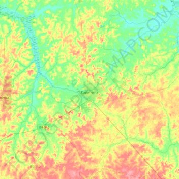
Название: Топографическая карта Capanema, высота, рельеф.
Средняя высота: 32 м
Минимальная высота: 0 м
Максимальная высота: 77 м
Сделать пожертвование
Другие топографические карты
Нажмите на карту, чтобы просмотреть ее топографию, ее высоту и ее рельеф.
Amazon River
During what many archaeologists called the formative stage, Amazonian societies were deeply involved in the emergence of South America's highland agrarian systems. The trade with Andean civilizations in the terrains of the headwaters in the Andes formed an essential contribution to the social and religious…
Средняя высота: 9 м
Amazon River
During what many archaeologists called the formative stage, Amazonian societies were deeply involved in the emergence of South America's highland agrarian systems. The trade with Andean civilizations in the terrains of the headwaters in the Andes formed an essential contribution to the social and religious…
Средняя высота: 19 м
Сделать пожертвование
Amazon River
During what many archaeologists called the formative stage, Amazonian societies were deeply involved in the emergence of South America's highland agrarian systems. The trade with Andean civilizations in the terrains of the headwaters in the Andes formed an essential contribution to the social and religious…
Средняя высота: 5 м
Сделать пожертвование
Amazon River
During what many archaeologists called the formative stage, Amazonian societies were deeply involved in the emergence of South America's highland agrarian systems. The trade with Andean civilizations in the terrains of the headwaters in the Andes formed an essential contribution to the social and religious…
Средняя высота: 4 м
Сделать пожертвование
Amazon River
During what many archaeologists called the formative stage, Amazonian societies were deeply involved in the emergence of South America's highland agrarian systems. The trade with Andean civilizations in the terrains of the headwaters in the Andes formed an essential contribution to the social and religious…
Средняя высота: 5 м
Сделать пожертвование
Сделать пожертвование