
Сделать пожертвование
Топографическая карта Foz do Iguaçu
Нажмите на карту, чтобы отобразить высоту.
Сделать пожертвование
Foz do Iguaçu
The climate of the city is hot or warm throughout the year, due to the relatively low altitude (standing only 173 m, 567 ft (173 m), above sea level).
Сделать пожертвование
Об этой карте
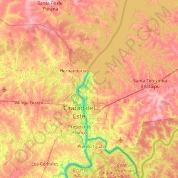
Название: Топографическая карта Foz do Iguaçu, высота, рельеф.
Средняя высота: 228 м
Минимальная высота: 89 м
Максимальная высота: 356 м
Сделать пожертвование
Другие топографические карты
Нажмите на карту, чтобы просмотреть ее топографию, ее высоту и ее рельеф.
Itaipu Dam
Brazil > Paraná > Foz do Iguaçu
325 metres (1,066 ft), entire dam including the 100 metres (330 ft) high Power Line 4 Pylons atop the Barrage 260 metres (850 ft), dam + the foundation inside water until the river floor 247 metres (810 ft), 196 metres (643 ft) high of roof reinforcement concrete dam + Cranes atop the Barrage 225 metres (738…
Средняя высота: 192 м
Сделать пожертвование
Curitiba
Brazil > Paraná > Região Metropolitana de Curitiba
The city covers 432.17 km2 (166.86 sq mi) on the First Plateau of Paraná. Curitiba has a topography of smooth, rounded hills, giving it a relatively regular shape. The city has an average altitude of 934.6 m (3,066 ft) above sea level. The highest point is to the north at 1,021 m (3,350 ft), and with lower…
Средняя высота: 931 м
Сделать пожертвование
Tijucas do Sul
Brazil > Paraná > Região Metropolitana de Curitiba > Tijucas do Sul > Tijucas do Sul
Средняя высота: 913 м
Сделать пожертвование
Сделать пожертвование