
Сделать пожертвование
Топографическая карта Fernando de Noronha
Нажмите на карту, чтобы отобразить высоту.
Сделать пожертвование
Fernando de Noronha
Fernando de Noronha (Brazilian Portuguese pronunciation: [feʁˈnɐ̃du dʒi noˈɾoɲɐ]), officially the State District of Fernando de Noronha (Portuguese: Distrito Estadual de Fernando de Noronha) and formerly known as the Federal Territory of Fernando de Noronha (Território Federal de Fernando de Noronha) until 1988, is an archipelago in the Atlantic Ocean, part of the state of Pernambuco, Brazil, and located 354 km (191 nmi; 220 mi) off the Brazilian coast. It consists of 21 islands and islets, extending over an area of 26 km2 (10 sq mi). Only the eponymous main island is inhabited; it has an area of 18.4 km2 (7.1 sq mi) and a population estimated at 3,101 in 2020. While most of the archipelago is relatively low-lying, there are parts reaching more than 100 m (328 ft) in elevation.
Сделать пожертвование
Об этой карте
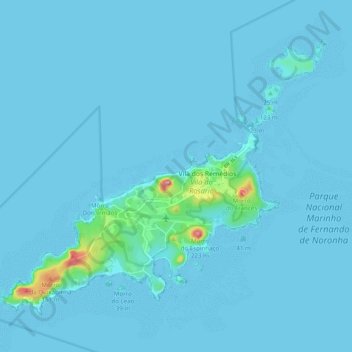
Название: Топографическая карта Fernando de Noronha, высота, рельеф.
Местонахождение: Fernando de Noronha, Região Geográfica Imediata do Recife, Pernambuco, Northeast Region, 53990-000, Brazil (-3.88136 -32.47616 -3.80476 -32.37788)
Средняя высота: 9 м
Минимальная высота: 0 м
Максимальная высота: 225 м
Сделать пожертвование
Другие топографические карты
Нажмите на карту, чтобы просмотреть ее топографию, ее высоту и ее рельеф.
Ana de Alburquerque
Brazil > Pernambuco > Região Metropolitana do Recife > Igarassu
Средняя высота: 17 м
Сделать пожертвование
Boa Paz
Brazil > Pernambuco > Região Administrativa Integrada de Desenvolvimento do Polo Petrolina e Juazeiro > Petrolina
Средняя высота: 379 м
Fernando de Noronha
Fernando de Noronha (Portuguese pronunciation: [feʁˈnɐ̃du dʒi noˈɾoɲɐ]) is an archipelago in the Atlantic Ocean, part of the State of Pernambuco, Brazil, and located 354 km (191 nmi; 220 mi) off the Brazilian coast. It consists of 21 islands and islets, extending over an area of 26 km2 (10 sq mi).…
Средняя высота: 4 м
Сделать пожертвование
Saint Peter and Saint Paul Archipelago
The Saint Peter and Saint Paul Rocks are situated in the Atlantic Ocean, 100 km (62 mi) north of the Equator, and are the only group of Brazilian oceanic islets in the Northern Hemisphere. The nearest point in the Brazilian coast, is Cabo do Calcanhar, Rio Grande do Norte, approximately 1,010 kilometres (630…
Средняя высота: 0 м