
Топографическая карта La Foux
Интерактивная карта
Нажмите на карту, чтобы отобразить высоту.
Об этой карте
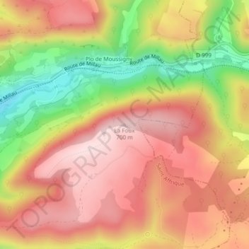
Название: Топографическая карта La Foux, высота, рельеф.
Местонахождение: La Foux, Saint-Affrique, Millau, Aveyron, Occitanie, France métropolitaine, 12400, France (43.94801 2.93376 43.94811 2.93386)
Средняя высота: 567 м
Минимальная высота: 375 м
Максимальная высота: 697 м
Другие топографические карты
Нажмите на карту, чтобы просмотреть ее топографию, ее высоту и ее рельеф.
Les Combes
France > Occitanie > Aveyron > Saint-Affrique
Les Combes, Saint-Affrique, Millau, Aveyron, Occitanie, France métropolitaine, 12400, France
Средняя высота: 469 м
Vaxergues-le-Bas
France > Occitanie > Aveyron > Saint-Affrique
Vaxergues-le-Bas, Saint-Affrique, Millau, Aveyron, Occitanie, France métropolitaine, 12400, France
Средняя высота: 442 м
Maxillou
France > Occitanie > Aveyron > Saint-Affrique
Maxillou, Saint-Affrique, Millau, Aveyron, Occitanie, France métropolitaine, 12400, France
Средняя высота: 508 м
La Capelle
France > Occitanie > Aveyron > Saint-Affrique
La Capelle, Saint-Affrique, Millau, Aveyron, Occitanie, France métropolitaine, 12400, France
Средняя высота: 460 м
Maxillou
France > Occitanie > Aveyron > Saint-Affrique
Maxillou, Saint-Affrique, Millau, Aveyron, Occitanie, France métropolitaine, 12400, France
Средняя высота: 470 м