
Сделать пожертвование
Топографическая карта Anthony
Нажмите на карту, чтобы отобразить высоту.
Сделать пожертвование
Anthony
Anthony has a desert climate, with a high degree of diurnal temperature variation due to the relatively high elevation and aridity.
Сделать пожертвование
Об этой карте
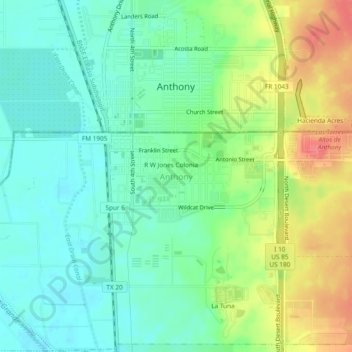
Название: Топографическая карта Anthony, высота, рельеф.
Местонахождение: Anthony, El Paso County, Texas, 79821, United States (31.97565 -106.61682 32.01565 -106.57682)
Средняя высота: 1 173 м
Минимальная высота: 1 147 м
Максимальная высота: 1 220 м
Сделать пожертвование
Другие топографические карты
Нажмите на карту, чтобы просмотреть ее топографию, ее высоту и ее рельеф.
El Paso
United States > Texas > El Paso County
El Paso is characterized by a diverse and striking topography shaped by its desert environment and mountainous landscapes. The city is situated at an average elevation of approximately 3,700 feet above sea level, surrounded by the rugged Franklin Mountains to the west, where peaks exceed 7,000 feet. This…
Средняя высота: 1 237 м
Anthony
United States > Texas > El Paso County
Anthony has a desert climate, with a high degree of diurnal temperature variation due to the relatively high elevation and aridity.
Средняя высота: 1 176 м
Сделать пожертвование
El Paso
United States > Texas > El Paso County
El Paso County was established in March 1850, with San Elizario as the first county seat. The United States Senate fixed a boundary between Texas and New Mexico at the 32nd parallel, thus largely ignoring history and topography. A military post called the "Post opposite El Paso" (meaning opposite El Paso del…
Средняя высота: 1 237 м
Сделать пожертвование
El Paso
United States > Texas > El Paso County
El Paso County was established in March 1850, with San Elizario as the first county seat. The United States Senate fixed a boundary between Texas and New Mexico at the 32nd parallel, thus largely ignoring history and topography. A military post called the "Post opposite El Paso" (meaning opposite El Paso del…
Средняя высота: 1 237 м
Сделать пожертвование