
Сделать пожертвование
Топографическая карта Buru Island
Нажмите на карту, чтобы отобразить высоту.
Сделать пожертвование
Buru Island
The Apo River is the longest river of Buru. It flows nearly straight to the north-east and empties into Kayeli Bay; however, its bed is very winding for hundreds of meters, with loops all along its length. Two other permanent rivers are Geren and Nibe; the rest are intermittent rivers with discontinuous flow. The river discharge varies significantly through the year, reaching a maximum in the rainy season. Indonesian sources often include wae (meaning river) before the river names; thus Apo is often referred to as Waeapo or Wae Apo, or Apu in some local dialects. In the center of the island, at an altitude of 767 metres (2,516 ft), lies freshwater Lake Rana (Indonesian: Danau Rana). This is the only significant lake on Buru; it has a nearly rectangular shape with the length of about 4.3 km, width of about 2.7 km and an area of 11.5 km2 (4.4 sq mi)
Сделать пожертвование
Об этой карте
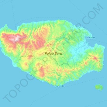
Название: Топографическая карта Buru Island, высота, рельеф.
Местонахождение: Buru Island, Maluku, Indonesia (-3.86176 125.99535 -3.05636 127.26884)
Средняя высота: 236 м
Минимальная высота: 0 м
Максимальная высота: 2 634 м
Сделать пожертвование
Другие топографические карты
Нажмите на карту, чтобы просмотреть ее топографию, ее высоту и ее рельеф.
Сделать пожертвование
Сделать пожертвование
Сделать пожертвование
Сделать пожертвование
Сделать пожертвование
Сделать пожертвование
Сделать пожертвование
Сделать пожертвование
Сделать пожертвование
Сделать пожертвование