
Сделать пожертвование
Топографическая карта Frostburg
Нажмите на карту, чтобы отобразить высоту.
Сделать пожертвование
Frostburg
Due to its average elevation of 2,000 feet (610 m) above sea level and location near the Allegheny Front, Frostburg has a colder, wetter climate than much of the rest of the state, and falls in USDA hardiness zone 6b. Under the Köppen climate classification, it has a humid continental climate (Dfb), with cold, snowy winters, and warm, humid summers. The daily mean temperature ranges from 26.0 °F (−3.3 °C) in January to 69.0 °F (20.6 °C) in July. Sub-0 °F (−18 °C) occur on 3.8 nights per year, while, on average, there are 1.4 days with 90 °F (32 °C)+ highs, though these are not recorded every year. Due to orographic lift, driving conditions on I-68 and US 40 can be very hazardous despite timely state and local road maintenance services, and the town averages just over 80 inches (200 cm) of snowfall a season; significant falls can occur as early as October and as late as May. Frostburg's greatest one-month snowfall was 67 inches (170 cm) in January 1978, and Frostburg is second in Maryland for the greatest single-season snowfall with a total of 180 inches (460 cm) in the winter of 1995−96.
Сделать пожертвование
Об этой карте
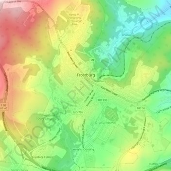
Название: Топографическая карта Frostburg, высота, рельеф.
Местонахождение: Frostburg, Allegany County, Maryland, 21532, United States (39.63471 -78.95116 39.67617 -78.90082)
Средняя высота: 620 м
Минимальная высота: 456 м
Максимальная высота: 822 м
Сделать пожертвование
Другие топографические карты
Нажмите на карту, чтобы просмотреть ее топографию, ее высоту и ее рельеф.