
Топографическая карта Eureka Springs
Интерактивная карта
Нажмите на карту, чтобы отобразить высоту.
Об этой карте
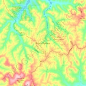
Название: Топографическая карта Eureka Springs, высота, рельеф.
Местонахождение: Eureka Springs, Carroll County, Arkansas, 72632, United States (36.36008 -93.77924 36.44008 -93.69924)
Средняя высота: 417 м
Минимальная высота: 311 м
Максимальная высота: 541 м
It is a tourist destination for its unique character as a Victorian resort village. The city has steep winding streets filled with Victorian-style cottages and manors. The historic commercial downtown of the city has an extensive streetscape of well-preserved Victorian buildings. The buildings are primarily constructed of local stone, built along streets that curve around the hills and rise and fall with the topography in a five-mile long loop. Some buildings have street-level entrances on more than one floor and other such oddities: the Basin Park Hotel has its front entrances on the floor below first, and a ground-level emergency exit in the back of the building on the fifth floor. The streets wind around the town, with few intersecting at right angles. There are no traffic lights.