
Топографическая карта Mâle
Интерактивная карта
Нажмите на карту, чтобы отобразить высоту.
Об этой карте
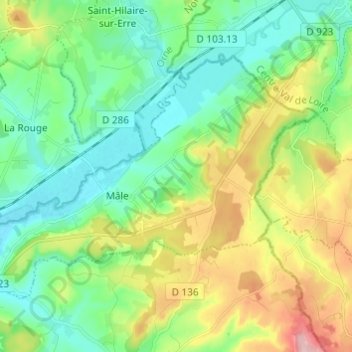
Название: Топографическая карта Mâle, высота, рельеф.
Местонахождение: Mâle, Val-au-Perche, Mortagne-au-Perche, Orne, Normandie, France métropolitaine, 61260, France (48.24773 0.68686 48.30381 0.80808)
Средняя высота: 149 м
Минимальная высота: 91 м
Максимальная высота: 273 м
Другие топографические карты
Нажмите на карту, чтобы просмотреть ее топографию, ее высоту и ее рельеф.
La Taille
France > Normandie > Orne > Val-au-Perche
La Taille, Le Theil, Val-au-Perche, Mortagne-au-Perche, Orne, Normandie, France métropolitaine, 61260, France
Средняя высота: 123 м
Le Theil
France > Normandie > Orne > Val-au-Perche
Le Theil, Val-au-Perche, Mortagne-au-Perche, Orne, Normandie, France métropolitaine, 61260, France
Средняя высота: 141 м
Beaulieu
France > Normandie > Orne > Val-au-Perche
Beaulieu, Saint-Agnan-sur-Erre, Val-au-Perche, Mortagne-au-Perche, Orne, Normandie, France métropolitaine, 61340, France
Средняя высота: 132 м
L'Hermitière
France > Normandie > Orne > Val-au-Perche
L'Hermitière, Val-au-Perche, Mortagne-au-Perche, Orne, Normandie, France métropolitaine, 61260, France
Средняя высота: 156 м
Gémages
France > Normandie > Orne > Val-au-Perche
Gémages, Val-au-Perche, Mortagne-au-Perche, Orne, Normandie, France métropolitaine, 61130, France
Средняя высота: 146 м
La Rouge
France > Normandie > Orne > Val-au-Perche
La Rouge, Val-au-Perche, Mortagne-au-Perche, Orne, Normandie, France métropolitaine, 61260, France
Средняя высота: 127 м
La Monnerie
France > Normandie > Orne > Val-au-Perche
La Monnerie, Gémages, Val-au-Perche, Mortagne-au-Perche, Orne, Normandie, France métropolitaine, 61130, France
Средняя высота: 137 м