
Сделать пожертвование
Топографическая карта Pennygate
Нажмите на карту, чтобы отобразить высоту.
Сделать пожертвование
Об этой карте
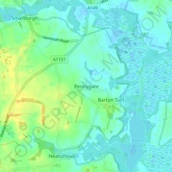
Название: Топографическая карта Pennygate, высота, рельеф.
Местонахождение: Pennygate, North Norfolk, Norfolk, England, NR12 8BG, United Kingdom (52.73219 1.45755 52.77219 1.49755)
Средняя высота: 7 м
Минимальная высота: -2 м
Максимальная высота: 23 м
Сделать пожертвование
Другие топографические карты
Нажмите на карту, чтобы просмотреть ее топографию, ее высоту и ее рельеф.
Walsingham
United Kingdom > England > Norfolk > North Norfolk
The River Stiffkey flows through the parish, from south to north, passing to the east of bulk of the village. The centre of Little Walsingham is at an elevation of around 17 metres (56 ft) and lies within the Stiffkey valley, with the land rising to the east and west — to the west it rises to around 75…
Средняя высота: 43 м
Сделать пожертвование
Сделать пожертвование
Сделать пожертвование
Сделать пожертвование
Сделать пожертвование
Сделать пожертвование
Сделать пожертвование
Sheringham Park
United Kingdom > England > Norfolk > North Norfolk > Upper Sheringham
Средняя высота: 61 м
Сделать пожертвование
Сделать пожертвование
Сделать пожертвование
Knapton
United Kingdom > England > Norfolk > North Norfolk
The present church dates from mainly the 14th century. The tower is set into the north west corner of the building. The porch is on the southern elevation. Atop of the church there is a weathervane designed by J.S. Cotman an artist famed as a member of the Norwich school. Inside there is a 13th-century font on…
Средняя высота: 29 м
Сделать пожертвование
North Walsham and Dilham Canal
United Kingdom > England > Norfolk > North Norfolk > Honing
Средняя высота: 21 м
Сделать пожертвование
Сделать пожертвование
Сделать пожертвование
Сделать пожертвование
Сделать пожертвование
Сделать пожертвование
Hanworth
United Kingdom > England > Norfolk > North Norfolk
The parish church of Saint Bartholomew dates from the 14th century but parts of the building date from an earlier building. On the outside north wall of the chancel , there are traces of Saxon windows. On the eastern elevation, the east window dates from between 1290 and 1350. The nave and south aisles are of…
Средняя высота: 35 м
Сделать пожертвование
Little Snoring
United Kingdom > England > Norfolk > North Norfolk > Little Snoring
Средняя высота: 53 м
Сделать пожертвование
Сделать пожертвование
Сделать пожертвование
Сделать пожертвование
Сделать пожертвование
Сделать пожертвование
Сделать пожертвование