
Сделать пожертвование
Топографическая карта Ella
Нажмите на карту, чтобы отобразить высоту.
Сделать пожертвование
Ella
Ella (Sinhala: ඇල්ල, lit. 'fall'; Tamil: எல்ல) is a small town in the Badulla District of Uva Province, Sri Lanka governed by an Urban Council. It is approximately 200 kilometres (120 mi) east of Colombo and is situated at an elevation of 1,041 metres (3,415 ft) above sea level. The area has a rich bio-diversity, dense with numerous varieties of flora and fauna. Ella is surrounded by hills covered with cloud forests and tea plantations. The town has a cooler climate than surrounding lowlands, due to its elevation. The Ella Gap allows views across the southern plains of Sri Lanka.
Сделать пожертвование
Об этой карте
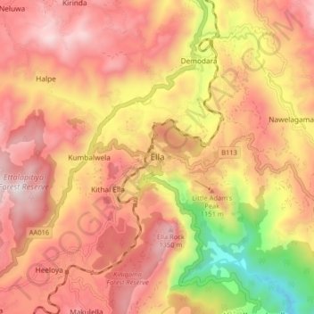
Название: Топографическая карта Ella, высота, рельеф.
Местонахождение: Ella, Badulla District, Uva Province, 90090, Sri Lanka (6.83361 81.00899 6.91361 81.08899)
Средняя высота: 1 021 м
Минимальная высота: 348 м
Максимальная высота: 1 443 м
Сделать пожертвование
Другие топографические карты
Нажмите на карту, чтобы просмотреть ее топографию, ее высоту и ее рельеф.
Yala National Park
The Yala area is mostly composed of metamorphic rock belonging to the Precambrian era and classified into two series, Vijayan series and Highland series. Reddish brown soil and low humic grey soil are prominent among six soil types. Yala is situated in the lowest peneplain of Sri Lanka, which extends from…
Средняя высота: 65 м