
Сделать пожертвование
Топографическая карта Nigüelas
Нажмите на карту, чтобы отобразить высоту.
Сделать пожертвование
Об этой карте
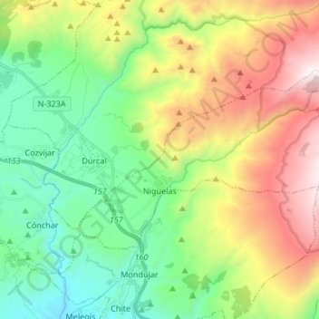
Название: Топографическая карта Nigüelas, высота, рельеф.
Местонахождение: Nigüelas, Partido Judicial de Granada, Granada, Andalusia, Spain (36.95831 -3.57348 37.01813 -3.43962)
Средняя высота: 1 212 м
Минимальная высота: 508 м
Максимальная высота: 2 449 м
Сделать пожертвование
Другие топографические карты
Нажмите на карту, чтобы просмотреть ее топографию, ее высоту и ее рельеф.
Alhambra
Spain > Andalusia > Partido Judicial de Granada > Granada
During the reign of the Nasrid Dynasty, the Alhambra was transformed into a palatine city, complete with an irrigation system composed of aqueducts and water channels that provided water for the complex and for other nearby countryside palaces such as the Generalife. Previously, the old fortresses on the hill…
Средняя высота: 759 м