
Спасибо за поддержку этого сайта ❤️
Сделать пожертвование
Сделать пожертвование
Топографическая карта Dhanbad
Нажмите на карту, чтобы отобразить высоту.
Спасибо за поддержку этого сайта ❤️
Сделать пожертвование
Сделать пожертвование
Dhanbad
Dhanbad has an average elevation of 227 m (745 ft). Its geographical length (extending from north to south) is 15 miles (24 km) and the breadth (stretching across east to West) is 10 miles (16 km). It shares its boundaries with West Bengal in the eastern and southern part, Giridih and Dumka in the North and Bokaro District in the west. Dhanbad comes under the Chota Nagpur Plateau.
Спасибо за поддержку этого сайта ❤️
Сделать пожертвование
Сделать пожертвование
Об этой карте
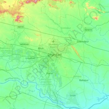
Название: Топографическая карта Dhanbad, высота, рельеф.
Местонахождение: Dhanbad, Dhanbad-Cum-Kenduadih-Cum-Jagata, Dhanbad, Jharkhand, 826001, India (23.63528 86.27096 23.95528 86.59096)
Средняя высота: 212 м
Минимальная высота: 113 м
Максимальная высота: 633 м
Спасибо за поддержку этого сайта ❤️
Сделать пожертвование
Сделать пожертвование