
Сделать пожертвование
Топографическая карта Scenic View
Нажмите на карту, чтобы отобразить высоту.
Сделать пожертвование
Об этой карте
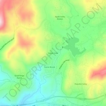
Название: Топографическая карта Scenic View, высота, рельеф.
Местонахождение: Scenic View, Tuolumne County, California, 95370, United States (37.97770 -120.35214 38.01770 -120.31214)
Средняя высота: 765 м
Минимальная высота: 613 м
Максимальная высота: 998 м
Сделать пожертвование
Другие топографические карты
Нажмите на карту, чтобы просмотреть ее топографию, ее высоту и ее рельеф.
Sonora
United States > California > Tuolumne County
Sonora is located at 37°59′04″N 120°22′54″W / 37.984361°N 120.381767°W / 37.984361; -120.381767, around the intersection of California State Highways 49 and 108 The altitude is 1,825 feet (556 m). According to the United States Census Bureau, the city has a total area of 3.1 square miles…
Средняя высота: 615 м
Twain Harte
United States > California > Tuolumne County
Twain Harte is situated in Tuolumne County along Highway 108 at an elevation of 3,640 feet (1,110 m).
Средняя высота: 1 123 м
Сделать пожертвование
Сделать пожертвование
Sonora
United States > California > Tuolumne County
Sonora is located around the intersection of California State Highways 49 and 108 The altitude is 1,825 feet (556 m). According to the United States Census Bureau, the city covers a total area of 3.2 square miles (8.3 km2), making it the county's largest community by land area. 99.57% of the area is land and…
Средняя высота: 614 м
Сделать пожертвование
Tuolumne Meadows
United States > California > Tuolumne County > Tuolumne Meadows
Средняя высота: 2 668 м
Сделать пожертвование
Sonora
United States > California > Tuolumne County
Sonora is located at 37°59′04″N 120°22′54″W / 37.984361°N 120.381767°W / 37.984361; -120.381767, around the intersection of California State Highways 49 and 108 The altitude is 1,825 feet (556 m). According to the United States Census Bureau, the city has a total area of 3.1 square miles…
Средняя высота: 615 м
Сделать пожертвование
Columbia
United States > California > Tuolumne County
Columbia is located along State Route 49 just north of Sonora, at an altitude of 2,139 feet (652 m).
Средняя высота: 672 м
Сделать пожертвование