
Топографическая карта Kottayam
Интерактивная карта
Нажмите на карту, чтобы отобразить высоту.
Kottayam
Kottayam has an average elevation of 3 metres (9.8 ft) above sea level. and is situated in the basin of the Meenachil River and in the basin of the Vembanad backwaters, which are formed from several streams in the Western Ghats in Idukki district. According to the division of places in Kerala based on altitudes, Kottayam is classified as being a midland area. The general soil type is alluvial soil. The vegetation is mainly tropical evergreen and moist deciduous type.
Об этой карте
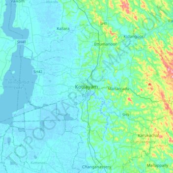
Название: Топографическая карта Kottayam, высота, рельеф.
Местонахождение: Kottayam, Kottayam District, Kerala, 686001, India (9.43156 76.36216 9.75156 76.68216)
Средняя высота: 19 м
Минимальная высота: -4 м
Максимальная высота: 157 м
Другие топографические карты
Нажмите на карту, чтобы просмотреть ее топографию, ее высоту и ее рельеф.