
Сделать пожертвование
Топографическая карта Kingman
Нажмите на карту, чтобы отобразить высоту.
Сделать пожертвование
Kingman
Lt. Edward Fitzgerald Beale, a U.S. Navy officer in the service of the Army Corps of Topographical Engineers, was ordered by the U.S. War Department to build a federal wagon road across the 35th parallel. His secondary orders were to test the feasibility of the use of camels as pack animals in the Southwestern desert. Beale traveled through the present-day Kingman in 1857 surveying the road and in 1859 to build the road. Beale's Wagon Road became part of U.S. Route 66 and later Interstate 40. Remnants of the wagon road can still be seen in White Cliffs Canyon in Kingman.
Сделать пожертвование
Об этой карте
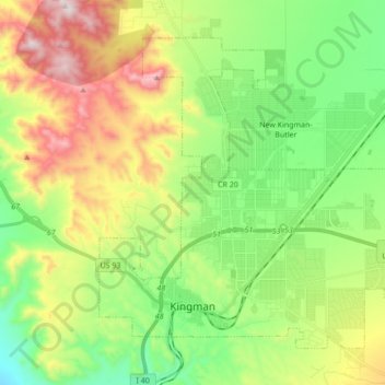
Название: Топографическая карта Kingman, высота, рельеф.
Местонахождение: Kingman, Mohave County, Arizona, United States (35.17405 -114.09481 35.28733 -113.92299)
Средняя высота: 1 131 м
Минимальная высота: 827 м
Максимальная высота: 1 648 м
Сделать пожертвование
Другие топографические карты
Нажмите на карту, чтобы просмотреть ее топографию, ее высоту и ее рельеф.
Hoover Dam
United States > Arizona > Mohave County
The amount of electricity generated by Hoover Dam has been decreasing along with the falling water level in Lake Mead due to the prolonged drought since year 2000 and high demand for the Colorado River's water. By 2014 its generating capacity was downrated by 23% to 1592 MW and was providing power only during…
Средняя высота: 429 м
Сделать пожертвование
Сделать пожертвование
Сделать пожертвование
Сделать пожертвование
Oatman
United States > Arizona > Mohave County
Oatman is a census-designated place (CDP) in the Black Mountains of Mohave County, Arizona, United States, at an elevation of 2,710 feet (830 m). In 1915, it began as a small mining camp when two prospectors struck US$10 million (equivalent to $176 million in 2024) in gold, though the vicinity had already been…
Средняя высота: 894 м
Hoover Dam
United States > Arizona > Mohave County
The amount of electricity generated by Hoover Dam has been decreasing along with the falling water level in Lake Mead due to the prolonged drought since year 2000 and high demand for the Colorado River's water. By 2014 its generating capacity was downrated by 23% to 1592 MW and was providing power only during…
Средняя высота: 429 м
Сделать пожертвование
Сделать пожертвование
Pigeon Point Lighthouse
United States > Arizona > Mohave County > Lake Havasu City
Средняя высота: 155 м
Сделать пожертвование
Сделать пожертвование
Hoover Dam
United States > Arizona > Mohave County
The amount of electricity generated by Hoover Dam has been decreasing along with the falling water level in Lake Mead due to the prolonged drought in the 2010s and high demand for the Colorado River's water. Lake Mead fell to a new record low elevation of 1,071.61 feet (326.63 m) on July 1, 2016 before…
Средняя высота: 429 м
Сделать пожертвование