
Сделать пожертвование
Топографическая карта Sent
Нажмите на карту, чтобы отобразить высоту.
Сделать пожертвование
Об этой карте
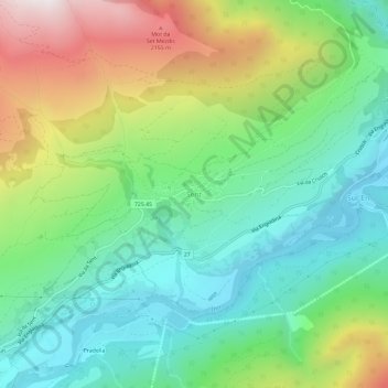
Название: Топографическая карта Sent, высота, рельеф.
Местонахождение: Sent, Scuol, Region Engiadina Bassa/Val Müstair, Grisons, 7554, Switzerland (46.79697 10.31767 46.83697 10.35767)
Средняя высота: 1 533 м
Минимальная высота: 1 107 м
Максимальная высота: 2 366 м
Сделать пожертвование
Другие топографические карты
Нажмите на карту, чтобы просмотреть ее топографию, ее высоту и ее рельеф.
Scuol
Switzerland > Grisons > Region Engiadina Bassa/Val Müstair
The God da Tamangur ("the forest back there") is the highest continuous stone pine (pinus cembra) forest in Europe, right at the furthest end of the Val S-charl, south of Scuol. The forest nature reserve covers an area of about 84 ha (210 acres) at up to 2,400 m (7,900 ft) in elevation. Due to the altitude and…
Средняя высота: 2 240 м
Zernez
Switzerland > Grisons > Region Engiadina Bassa/Val Müstair
Lai da Ova Spin is a compensation reservoir on the river Spöl. It is located in the upper areas of the Lower Engadine valley (Romansh: Engiadina Bassa). It is located at an elevation of 1,473 m (4,833 ft) and is connected to the railway network of the Rhätische Bahn. In Zernez, the stream Spöl empties into…
Средняя высота: 2 297 м
Swiss National Park
Switzerland > Grisons > Region Engiadina Bassa/Val Müstair
Средняя высота: 2 283 м