
Топографическая карта Spences Bridge
Интерактивная карта
Нажмите на карту, чтобы отобразить высоту.
Об этой карте
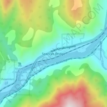
Название: Топографическая карта Spences Bridge, высота, рельеф.
Местонахождение: Spences Bridge, Area I (Blue Sky Country), Thompson-Nicola Regional District, British Columbia, V0K 2L0, Canada (50.40309 -121.36365 50.44309 -121.32365)
Средняя высота: 495 м
Минимальная высота: 213 м
Максимальная высота: 1 195 м
Spences Bridge's location is mountainous, with higher elevations part of the Interior Plateau. The east side of the Fraser here is part of the Clear Range, a mountainous southwards extension of the Fraser Plateau located in the angle of the Thompson and Fraser Rivers. Arthur Seat lies in that range on the west side of Spences Bridge, and was named by pioneer John Murray for Arthur's Seat in Edinburgh, Scotland.
Другие топографические карты
Нажмите на карту, чтобы просмотреть ее топографию, ее высоту и ее рельеф.
Walhachin
Canada > British Columbia > Thompson-Nicola Regional District > Area I (Blue Sky Country)
Walhachin, Area I (Blue Sky Country), Thompson-Nicola Regional District, British Columbia, Canada
Средняя высота: 438 м
Barnes Lake
Canada > British Columbia > Thompson-Nicola Regional District > Area I (Blue Sky Country)
Barnes Lake, Area I (Blue Sky Country), Thompson-Nicola Regional District, British Columbia, Canada
Средняя высота: 752 м
Shaw Springs
Canada > British Columbia > Thompson-Nicola Regional District > Area I (Blue Sky Country)
Shaw Springs, Area I (Blue Sky Country), Thompson-Nicola Regional District, British Columbia, Canada
Средняя высота: 472 м