
Топографическая карта Caterham
Нажмите на карту, чтобы отобразить высоту.
Caterham
In 1840 Caterham contained a total of 477 residents (figures taken from that census, compiled in an 1848 topographical encyclopedia) and in 1848 468 acres (189 ha) of its 2,386 acres (966 ha) were common land. Similar to today, 175 acres (71 ha) mostly steeper acres were woodland.
Об этой карте
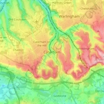
Название: Топографическая карта Caterham, высота, рельеф.
Местонахождение: Caterham, Tandridge, Surrey, England, CR3 6QA, United Kingdom (51.24220 -0.11725 51.32220 -0.03725)
Средняя высота: 157 м
Минимальная высота: 71 м
Максимальная высота: 269 м
Другие топографические карты
Нажмите на карту, чтобы просмотреть ее топографию, ее высоту и ее рельеф.
Warlingham
United Kingdom > England > Surrey > Tandridge
Elevations vary from 110m AOD at Woldingham Road, at the southernmost point of the parish, with a gentle increase in height through the village along the main road heading to the southeast, to the highest elevation (199.6m) at Limpsfield Road.
Средняя высота: 163 м