
Сделать пожертвование
Топографическая карта Kerrville
Нажмите на карту, чтобы отобразить высоту.
Сделать пожертвование
Kerrville
Kerrville is characterized by a diverse and rugged topography. Nestled along the Guadalupe River, it sits at an elevation averaging 1,600 feet above sea level, with varying terrain that includes gentle hills, steep slopes, and flat river valleys. This area features numerous limestone hills, characteristic of the Edwards Plateau, as well as smaller ridges and escarpments that create an intricate landscape. The terrain includes densely vegetated areas along the river and open fields across the rolling hills, providing distinct natural beauty and varied ecosystems. This rugged yet scenic region is marked by changes in elevation that add to its appeal for outdoor recreation, such as hiking and scenic drives, especially around the Guadalupe River and nearby creeks.
Сделать пожертвование
Об этой карте
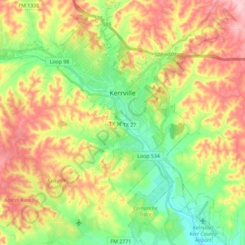
Название: Топографическая карта Kerrville, высота, рельеф.
Местонахождение: Kerrville, Kerr County, Texas, United States (29.96182 -99.21161 30.10132 -99.07165)
Средняя высота: 545 м
Минимальная высота: 464 м
Максимальная высота: 646 м
Сделать пожертвование
Другие топографические карты
Нажмите на карту, чтобы просмотреть ее топографию, ее высоту и ее рельеф.
Сделать пожертвование
Сделать пожертвование