
Топографическая карта Bella Coola
Интерактивная карта
Нажмите на карту, чтобы отобразить высоту.
Об этой карте
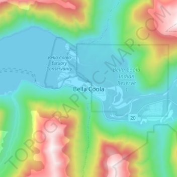
Название: Топографическая карта Bella Coola, высота, рельеф.
Средняя высота: 437 м
Минимальная высота: -1 м
Максимальная высота: 1 609 м
There is a 454 km mostly paved road connection by Highway 20 to Williams Lake. The road was built in 1953 by local residents, and features a 15 km ascent from the Valley floor to the Chilcotin plateau, gaining 1600m in elevation to the summit at Heckman Pass, via a number of steep grades & switchbacks. The construction of this road was described in the books "Bella Coola" and "A Road Runs West".