
Сделать пожертвование
Топографическая карта Gresham
Нажмите на карту, чтобы отобразить высоту.
Сделать пожертвование
Gresham
Gresham is characterized by hills on its eastern border. Northeast Gresham is also hilly, especially where the city meets Troutdale toward the Columbia River. Its elevation is 325 feet (99 m). Johnson Creek, which begins at the foothills of the Cascade Mountains, runs westward through Gresham, with 23 percent of the creek's watershed running through the city.
Сделать пожертвование
Об этой карте
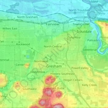
Название: Топографическая карта Gresham, высота, рельеф.
Местонахождение: Gresham, Multnomah County, Oregon, United States (45.46094 -122.49807 45.56088 -122.36758)
Средняя высота: 89 м
Минимальная высота: -2 м
Максимальная высота: 322 м
Сделать пожертвование
Другие топографические карты
Нажмите на карту, чтобы просмотреть ее топографию, ее высоту и ее рельеф.
Сделать пожертвование
Governor Tom McCall Waterfront Park
United States > Oregon > Multnomah County > Portland
Средняя высота: 26 м
Rocky Butte
United States > Oregon > Multnomah County > Portland
Rocky Butte lies in the northeast part of Portland within the city limits, in Multnomah County, part of the U. S. state of Oregon. It is one of the few smaller volcanic cones within or near Portland, along with Mount Tabor, Kelly Butte, and Powell Butte. According to the U.S. National Geodetic Survey, Rocky…
Средняя высота: 67 м
Сделать пожертвование
Сделать пожертвование
Сделать пожертвование