
Сделать пожертвование
Топографическая карта Ruivo
Нажмите на карту, чтобы отобразить высоту.
Сделать пожертвование
Ruivo
As the highest point in the archipelago, Pico Ruivo is primarily surrounded by high-altitude heath. The area is also marked by monumental rock formations, which often rise above the clouds, dominating the landscape. The region is home to several bird species, including the Madeira firecrest, the chaffinch, and the linnet.
Сделать пожертвование
Об этой карте
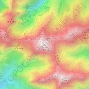
Название: Топографическая карта Ruivo, высота, рельеф.
Местонахождение: Ruivo, Santana, Madeira, 9230-000, Portugal (32.75883 -16.94281 32.75893 -16.94271)
Средняя высота: 1 400 м
Минимальная высота: 798 м
Максимальная высота: 1 837 м
Сделать пожертвование
Другие топографические карты
Нажмите на карту, чтобы просмотреть ее топографию, ее высоту и ее рельеф.
São Jorge
Fifty kilometres from the regional capital, the parish is located 240 metres above sea level, limited in the north by the Atlantic Ocean and south by the mountains of the interior range (the heightest altitudes in the parish include Pico Canário 1,592 metres (5,223 ft) and Pico dos Assumadouros 1,184 metres…
Средняя высота: 581 м
Сделать пожертвование