
Сделать пожертвование
Топографическая карта Canela
Нажмите на карту, чтобы отобразить высоту.
Сделать пожертвование
Canela
It is located at a latitude of 29º21'56" south and a longitude of 50º48'56" west, at an altitude of 837 meters. Its estimated population in 2018 was 44,489 inhabitants, according to the Brazilian Institute of Geography and Statistics. It has an area of 252.91 km², representing 0.0947 percent of the territory of Rio Grande do Sul.
Сделать пожертвование
Об этой карте
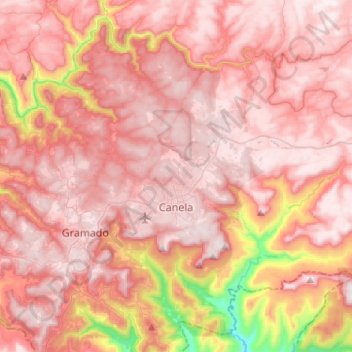
Название: Топографическая карта Canela, высота, рельеф.
Средняя высота: 670 м
Минимальная высота: 92 м
Максимальная высота: 904 м
Сделать пожертвование
Другие топографические карты
Нажмите на карту, чтобы просмотреть ее топографию, ее высоту и ее рельеф.
Estrada Carlos Dreyer
Brazil > Rio Grande do Sul > Metropolitan Region of Porto Alegre > Igrejinha
Средняя высота: 622 м
Сделать пожертвование
Porto Alegre
Brazil > Rio Grande do Sul > Metropolitan Region of Porto Alegre > Porto Alegre
Porto Alegre has a long coastline on the Guaíba Lake, and its topography is punctuated by 40 hills. In the lake, a vast body of water, a maze of islands facing the city creates an archipelago where a unique ecosystem gives shelter to abundant wildlife. The city area concentrates 28% of the native flora of Rio…
Средняя высота: 27 м
Сделать пожертвование
Сделать пожертвование
Parobé
Brazil > Rio Grande do Sul > Metropolitan Region of Porto Alegre > Parobé > Parobé
Средняя высота: 62 м
Сделать пожертвование
Pelotas
Brazil > Rio Grande do Sul > Aglomeração Urbana do Sul > Pelotas
As it is situated on a plain near the ocean, the urban area lies on a low elevation, being, on average, 7 meters (23 ft) above sea level. The interior of the municipality is on a plateau called Serras de Sudeste (Southeastern Mountain Ranges). Consequently, the altitude in Pelotas' rural area reaches 429…
Средняя высота: 18 м