
Топографическая карта Tarn Hows
Нажмите на карту, чтобы отобразить высоту.
Об этой карте
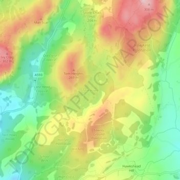
Название: Топографическая карта Tarn Hows, высота, рельеф.
Местонахождение: Tarn Hows, Coniston, Westmorland and Furness, England, United Kingdom (54.38820 -3.03773 54.39516 -3.02888)
Средняя высота: 187 м
Минимальная высота: 74 м
Максимальная высота: 315 м
Другие топографические карты
Нажмите на карту, чтобы просмотреть ее топографию, ее высоту и ее рельеф.
Old Man of Coniston
United Kingdom > England > Westmorland and Furness > Coniston
The first section rising steeply from Coniston is a metalled road, maintained partly to provide access to the quarry. This leads to a car park at an altitude of 740 ft (230 m), a popular starting point for climbs. Beyond here motor vehicles are prohibited, but the track continues to its summit at 2,000 ft (610…
Средняя высота: 501 м