
Топографическая карта Koshi River
Интерактивная карта
Нажмите на карту, чтобы отобразить высоту.
Об этой карте
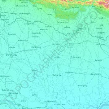
Название: Топографическая карта Koshi River, высота, рельеф.
Местонахождение: Koshi River, Bihar, India (25.40379 86.43871 26.91017 87.26669)
Средняя высота: 82 м
Минимальная высота: 24 м
Максимальная высота: 1 960 м
The Kosi River catchment covers six geological and climatic belts varying in altitude from above 8,000 m (26,000 ft) to 95 m (312 ft) comprising the Tibetan plateau, the Himalayas, the Himalayan mid-hill belt, the Mahabharat Range, the Siwalik Hills and the Terai. The Dudh-Koshi sub-basin alone consists of 36 glaciers and 296 glacier lakes. The Kosi River basin borders the Tsangpo River basin in the north, the Mahananda River basin in the east, the Ganges Basin in the south and the Gandaki River basin in the west. The eight tributaries of the basin upstream the Chatra Gorge include from east to west:
Другие топографические карты
Нажмите на карту, чтобы просмотреть ее топографию, ее высоту и ее рельеф.
Patna
India > Bihar > Patna Rural
Patna, Patna Rural, Patna District, Bihar, 800001, India
Средняя высота: 51 м
Sultanganj
India > Bihar > Sultanganj
Sultanganj, Bhagalpur District, Bihar, 812006, India
Средняя высота: 35 м
Parmanandpur
Parmanandpur, Basantpur, Supaul, Bihar, India
Средняя высота: 76 м
Gaya
India > Bihar > Gaya Town C.D.Block
Gaya, Gaya Town C.D.Block, Gaya District, Bihar, 823001, India
Средняя высота: 111 м
Baruraj (Motipur)
India > Bihar > Baruraj (Motipur)
Baruraj (Motipur), Muzaffarpur, Bihar, 843132, India
Средняя высота: 58 м
Manikpur
India > Bihar > Narpatganj
Manikpur, Narpatganj, Araria, Bihar, 854336, India
Средняя высота: 70 м